
Overview
Upper Mustang Trek — Complete Guide 2026
Few places on earth stop you in your tracks the way Upper Mustang does. You round a bend in the Kali Gandaki valley, step through a checkpoint where a soldier stamps your restricted-area permit, and within a kilometre the landscape transforms completely. The green terraced hills and rhododendron forests of the rest of Nepal simply disappear. In their place: an ancient Tibetan plateau in shades of rust, ochre, ivory, and deep crimson, carved by millennia of wind and water into a topography that belongs to a different geological era — and, in many ways, to a different civilisation entirely. Upper Mustang is Nepal’s last Himalayan kingdom, a place where Tibetan Buddhist culture, language, architecture, and daily life have survived virtually intact since the 14th century, shielded from the modern world by altitude, remoteness, and four decades of Nepalese government restrictions. Trekking here is not just a walk in the mountains. It is a journey into living history.
What Is Upper Mustang?
Upper Mustang refers to the northern section of the Mustang district of Gandaki Province, Nepal — a high-altitude plateau that borders the Tibet Autonomous Region of China. The region sits at an average elevation of 3,500–4,000 metres above sea level and covers approximately 2,000 square kilometres of what is essentially a Tibetan rain-shadow desert enclosed within Nepal’s political borders. The area is officially designated as the Mustang Restricted Area, requiring a special permit over and above the standard trekking permits required elsewhere in Nepal. The permit requirement, introduced in 1992 when Mustang was first opened to foreign visitors after centuries of isolation, is what has kept Upper Mustang from becoming overtouristed and has preserved its extraordinary cultural and natural character.
The main trekking corridor of Upper Mustang follows the upper Kali Gandaki river valley northward from Jomsom and Kagbeni, passing through a chain of medieval villages — Chele, Ghiling, Ghami, Tsarang — before arriving at Lo Manthang, the walled capital of the former Kingdom of Lo. The return can follow the same route or an alternative eastern path through Drakhmar, providing a fuller picture of the plateau’s landscape. Side excursions to Chhoser (the sky caves), Ghar Gompa, and Nyi La Pass are standard inclusions in any well-planned itinerary.
The Kingdom of Lo — A Living Medieval Kingdom
The Kingdom of Lo, known as Lomanthang in Tibetan, was founded in 1380 by Ame Pal, a Tibetan chieftain who unified the plateau’s scattered settlements under a single political authority. The walled capital city he built — Lo Manthang — still stands today, its perimeter walls, four great gompas, and royal palace largely unchanged from their medieval form. The kingdom operated as a semi-autonomous Tibetan Buddhist monarchy for over 600 years, even after its incorporation into the Kingdom of Nepal in the 18th century. The last king, Jigme Dorje Palbar Bista, held the throne until 2008, when Nepal abolished its monarchy and all royal titles were officially revoked. Though his formal political authority has ended, the former king remains a deeply revered figure in Lo Manthang and continues to reside in the palace, maintaining a ceremonial and cultural role in the life of the community.
The cultural continuity of the Kingdom of Lo is remarkable by any global standard. The people of Upper Mustang — the Lo-pa — speak a dialect of Tibetan, practice Tibetan Buddhism with strong elements of the older Bon tradition, dress in Tibetan-style chubas and fur-lined hats, grow barley, buckwheat, and mustard on terraced fields irrigated by glacier meltwater, and observe the same ritual calendar, monastery festivals, and agricultural customs their ancestors observed in the 14th century. The reason for this exceptional preservation is geography: the high walls of the Himalayan range to the south and the Tibetan plateau to the north created a natural isolation that limited outside influence for centuries.
The Rain Shadow Desert — Why Upper Mustang Looks Nothing Like Nepal
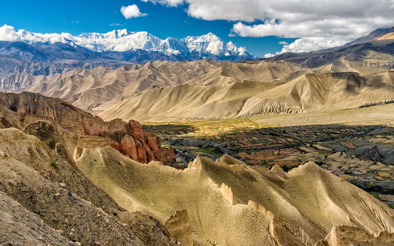
The single most dramatic feature of Upper Mustang for first-time visitors is the landscape itself. Nepal’s popular trekking routes — the Everest Base Camp trek, the Annapurna Circuit, the Langtang Valley — all share a broadly similar visual grammar: lush forested valleys, terraced agricultural hillsides, cascading rivers, and the permanent white of high glaciers. Upper Mustang looks nothing like any of these. It looks like the American Southwest — or more accurately, like the Tibetan plateau, which is exactly what it geologically is.
The reason is the Himalayan rain shadow. As monsoon clouds roll north from the Bay of Bengal each summer, they are blocked by the towering barrier of the main Himalayan range — Annapurna, Dhaulagiri, Nilgiri. The moisture falls on the southern slopes as rain and snow, nurturing the green valleys of lower Nepal. By the time the air mass reaches Upper Mustang, it has been wrung dry. The region receives less than 200 millimetres of precipitation per year — comparable to a desert in most climate classifications. This means the rock is exposed, the rivers run in deeply incised gorges, the hillsides are bare, and the wind scours the land with an intensity that would be extraordinary anywhere else. The colours that result — deep red iron oxide cliffs, white calcium-rich outcrops, ochre sandstone canyon walls, grey-purple shale ridges — create a visual palette unlike anything else in the Himalayas.
The wind is a character in its own right in Upper Mustang. In the Kali Gandaki valley especially, where the gorge acts as a wind tunnel between the great massifs of Annapurna and Dhaulagiri, afternoon winds routinely exceed 50–60 km/h and can reach gale force in spring and autumn. The upper plateau is somewhat sheltered from the worst of this, but no day in Mustang passes without wind. It has shaped the architecture — buildings are low, thick-walled, and flat-roofed. It has shaped the crops — only hardy cold-desert plants survive. And it has shaped the people, who move with the same calm deliberateness characteristic of those who live in extreme environments the world over.
Lo Manthang — The Walled City
Lo Manthang is the undisputed centrepiece of the Upper Mustang Trek. Sitting at 3,840 metres on an open plain ringed by ochre cliffs and distant snow peaks, the medieval walled city is one of the most extraordinary inhabited settlements in Asia. Its perimeter wall — roughly 200 by 300 metres — encloses a dense warren of whitewashed houses, narrow lanes, and four great monastery complexes that have been in continuous use for over 600 years. The wall itself, four to five metres high and built of packed clay and stone, is still substantially intact and gives the city the appearance of a fortress town from a medieval European landscape — though the culture within it is entirely and unmistakably Tibetan Buddhist.
The four main monasteries of Lo Manthang are Thubchen Gompa, Jampa Lhakhang, Chodey Gompa, and Namgyal Gompa. Of these, Thubchen is the most celebrated. Built in the late 14th century, it contains some of the finest surviving examples of Newar Buddhist mural painting from the Pala-influenced school — enormous wall paintings depicting the life of the Buddha, the mandalas of the five Dhyani Buddhas, and scenes from the Jataka tales, executed in mineral pigments that have retained much of their original intensity despite six centuries of dust and lamp soot. Conservation work supported by the American Himalayan Foundation and other international organisations has cleaned and stabilised significant portions of these murals in recent decades, and the results are breathtaking. Jampa Lhakhang, slightly older and dedicated to Maitreya (the future Buddha), contains a 15-metre clay statue of exceptional quality. Chodey Gompa is the active religious centre of the community, housing the resident monks and maintaining daily ritual life. Namgyal Gompa sits on a hilltop above the city and offers the best panoramic view over Lo Manthang and the plateau beyond.
The royal palace — a five-storey rammed-earth structure in the northeast corner of the walled city — is the largest private building in Lo Manthang. Though now largely uninhabited on its upper floors, it is still the residence of the former king and his family on ceremonial occasions. The ground floor contains a remarkable private gompa with older murals than those in the public monasteries. Entry is by arrangement and a small donation to the monastery fund is customary.
Life inside the walled city proceeds at its own rhythm, largely undisturbed by tourism. Women in traditional Tibetan dress carry water from the communal tap. Prayer wheels spin at the entrance to every household. Dogs sleep in the narrow lanes. Horses, essential for transport across the plateau, are tethered in the courtyards. The approximately 150 households that remain within the walls — many Lo-pa families have moved to Pokhara or Kathmandu in recent generations — maintain the agricultural and pastoral traditions of their ancestors: barley, buckwheat, and mustard in the fields surrounding the walls; dzos (yak-cattle hybrids) for ploughing and carrying; and the seasonal movement of herds to higher pastures in summer.
The Chhoser Sky Caves — Upper Mustang’s Most Mysterious Site
The Chhoser sky caves are among the most extraordinary archaeological sites in Asia and one of the most compelling reasons to spend an extra day in Lo Manthang. The site consists of a massive cliff face — perhaps 150 metres high — that has been honeycombed with thousands of man-made chambers excavated from the soft conglomerate rock at heights ranging from ground level to well above 50 metres. Some chambers are accessible by fixed ladders; others are so high that they can only be reached by rope. The caves were used across multiple periods for different purposes: the oldest, dating back more than 2,500 years, appear to have been funerary — excavations have recovered human skeletal remains, copper bowls, silk textiles with Chinese characteristics, and wooden artefacts that point to a sophisticated culture predating anything previously known from the Mustang plateau. Later caves were used as meditation cells by Buddhist monks, some fitted with small shrines and painted walls. The most recent period of use, probably ending in the 18th or 19th century, saw the caves adapted as defensive positions, with peepholes and arrow slits cut through the rock.
The archaeological significance of Chhoser cannot be overstated. The 2008–2014 excavation program led by Dr. Mark Aldenderfer of the University of California and Nepali archaeologist Mohan Singh Lama recovered finds that pushed back the known human occupation of the Mustang plateau by more than a millennium. DNA analysis of skeletal remains from the sky caves revealed a population genetically distinct from modern Lo-pa, suggesting a migration or cultural displacement at some point in the distant past. The site has been described by National Geographic, which funded several seasons of excavation, as among the most significant Himalayan archaeological discoveries of the 21st century.
Ghar Gompa — Nepal’s Oldest Monastery
Ghar Gompa, also known as Nyphu Gompa, sits on a narrow ledge above a precipitous canyon near the village of Ghami. Tradition holds that it was founded by Guru Rinpoche (Padmasambhava) himself in the 8th century, making it one of the oldest Buddhist monasteries in Nepal by any reckoning, and according to local tradition, the oldest. Whether or not the precise founding date is historically verifiable, there is no question that the site is extremely ancient — the style of the rock-cut chambers, the remnants of pre-classical Tibetan mural painting, and the form of the shrine objects all suggest antiquity well predating the established gompas of Lo Manthang. The monastery is small and the caretaker community minimal, but the setting — a narrow cliff-path approach over a roaring river, then a dramatic ascent to cave shrines with views across the canyon — is unforgettable. Most Upper Mustang trekking itineraries include Ghar Gompa as a side trip from Ghami, adding two to three hours to an otherwise straightforward stage.
The Kali Gandaki Gorge
The Kali Gandaki is one of the great rivers of the Himalayas. Rising in Tibet and flowing south through the heart of the Annapurna massif, it has carved a gorge between the peaks of Annapurna I (8,091 m) and Dhaulagiri (8,167 m) that is the deepest in the world by standard measurement — the river at its floor sits more than 5,500 metres below the summits on either side. The trekking route to Upper Mustang follows the upper Kali Gandaki northward from Jomsom, through the gravel riverbed and along the canyon walls, for the first two days. The scale of the landscape here is almost vertiginous: you are walking through a geological formation of extraordinary drama, flanked by two of the world’s fourteen eight-thousanders, on a route that has been used for at least two thousand years as the main salt-trade corridor between Tibet and the lowlands of Nepal and India.
Saligrams — ammonite fossils embedded in the black limestone riverbed — are found throughout the Kali Gandaki valley and are considered sacred objects in Hinduism, believed to be direct manifestations of Vishnu. Local people collect and sell them; pilgrims carry them home from the river. The sight of these ancient fossils — creatures that lived in a tropical sea before the Himalayas existed — in a river valley flanked by the world’s highest mountains provides an unexpected dimension of geological wonder to what is already a visually overwhelming route.
The Tiji Festival — Mustang’s Greatest Cultural Celebration
The Tiji Festival (Tenchi in Tibetan) is the most important religious celebration in Upper Mustang’s annual calendar and one of the most spectacular festival experiences available anywhere in the Himalayas. Held over three days in late spring — typically in May, on dates set by the Tibetan lunar calendar — Tiji commemorates the victory of the deity Dorje Jono over a demon who was bringing catastrophe to the Kingdom of Lo. The festival is enacted through an elaborate sequence of cham (masked ritual dance) performed by the monks of Choede Gompa in the courtyard of Lo Manthang’s main square, wearing the ornate Tibetan religious costumes and masks that are maintained specifically for this occasion. The costumes, some of which are centuries old, represent deities, animals, and supernatural beings from the Tibetan Buddhist cosmology. The dances narrate the myth across the three days in a sequence of set pieces, building to a dramatic climax on the final afternoon.
The entire population of Upper Mustang converges on Lo Manthang for Tiji, travelling from distant villages and seasonal pastures to participate. The walled city fills beyond its normal capacity with worshippers, and the surrounding plain becomes a temporary settlement of tents and improvised shelters. For trekkers fortunate enough to time their visit with the festival, it is a once-in-a-lifetime experience. Next Trip Nepal can plan your Upper Mustang Trek specifically around the Tiji Festival dates — contact us for the current year’s schedule.
Upper Mustang Trek Difficulty — Who Is This Trek For?
The Upper Mustang Trek is classified as moderate by standard trekking difficulty scales, and this rating is accurate provided you are adequately fit and have some understanding of high-altitude trekking. The trek does not involve technical climbing, glacier travel, fixed-rope sections, or any of the features that make routes like the Three Passes Trek or the Mera Peak climb demanding from a mountaineering standpoint. The trail itself is well-defined throughout, and in Upper Mustang proper, much of the route is jeepable (though walking is strongly preferred both for the experience and for the impact on the local economy). The maximum altitude reached is Nyi La Pass at 4,010 metres — lower than the passes on the Everest Base Camp trek and significantly lower than Thorong La on the Annapurna Circuit.
The challenges of the Upper Mustang Trek are different in character from those of higher-altitude routes. The wind is the most significant. In the lower Kali Gandaki valley, particularly between Jomsom and Kagbeni, afternoon winds can be extremely powerful and can make walking uncomfortable. Starting early (before 10 AM) and stopping by mid-afternoon avoids the worst of it. The terrain on some sections — loose scree, exposed ridges, deeply eroded canyon paths — requires attentiveness and reasonable balance. The remoteness of the route means that in the event of a medical emergency, evacuation can take longer than on more popular trekking corridors; travel insurance covering helicopter rescue is not optional, it is essential.
Who can do this trek? Fit adults with no significant cardiovascular or pulmonary conditions can complete the Upper Mustang Trek. Prior high-altitude trekking experience is helpful but not a prerequisite. The minimum age for trekking in Upper Mustang is generally considered to be around 10–12 years for children with appropriate conditioning and supervision. The maximum age is functionally unlimited — we have guided guests in their 70s and even 80s through Mustang, though these trips require slower pacing and additional acclimatisation days. Anyone with a recent history of altitude sickness should consult a physician before booking and discuss prophylactic use of Diamox (acetazolamide) with their doctor.
Best Time for the Upper Mustang Trek 2026
One of Upper Mustang’s most celebrated characteristics is its year-round accessibility. Because it sits in the Himalayan rain shadow, the region is viable for trekking in every month of the year — though each season has distinct characteristics that suit different types of trekkers.
Spring (March – May): The Prime Season
Spring is widely considered the best time to trek Upper Mustang. Temperatures are moderate — days can be warm at lower altitudes and pleasantly cool above 3,500 m, while nights are cold but not bitterly so. The sky is mostly clear, giving excellent visibility of the distant Himalayan peaks. The Kali Gandaki winds are at their strongest in spring afternoons, but manageable with early starts. March and April also bring wildflowers to the lower reaches of the valley — though Upper Mustang itself is too arid for the rhododendron displays you’d see in the middle hills. The Tiji Festival falls in May and is the single most compelling reason to time your visit to this month. Spring is also the busiest season in Upper Mustang (though “busy” is relative — the restricted permit system means the plateau never feels crowded).
Monsoon / Summer (June – September): The Secret Season
This is the counterintuitive recommendation that surprises most trekkers: the monsoon season is an excellent time to trek Upper Mustang, and in some respects the best. While the rest of Nepal is wet, cloudy, and prone to leech-infested trails and washed-out paths, Upper Mustang sits in the rain shadow and receives virtually no monsoon precipitation. The plateau stays dry. The sky is often clear above the Himalayan crest, with dramatic cloud formations building over the mountains to the south while the plateau itself basks in sunshine. Summer temperatures are the most comfortable of the year at altitude — days are warm and pleasant, nights are mild. Teahouses are less crowded and prices are sometimes lower. The fields around the villages are green with growing crops, providing an unexpected visual contrast with the red desert landscape beyond. For trekkers who can only travel in July or August, Upper Mustang is by far the best option in Nepal.
Autumn (September – November): Peak Season
Autumn shares the throne with spring as the most popular trekking season across Nepal, and Upper Mustang is no exception. Post-monsoon skies are crystalline — the atmosphere is washed clean by the rains, giving the sharpest mountain views of the year. The landscape takes on its richest colours as the barley harvest is brought in, the apples in Marpha and Kagbeni ripen, and the high-altitude grasses turn gold and rust. Temperatures are ideal throughout October and cool but manageable in early November. The winds in the Kali Gandaki are less severe than in spring. This is the optimal season for photography. Teahouses can be busy, especially on the approach from Jomsom to Kagbeni, but the restricted permit system limits numbers further north.
Winter (December – February): The Quiet Season
Winter in Upper Mustang is cold — genuinely cold — with temperatures dropping below −15°C at night above 3,500 m in January, and the teahouse infrastructure in some villages reduced or closed as families move to warmer lowland homes for the season. The Pokhara–Jomsom flights operate year-round, and Lo Manthang itself remains inhabited. For experienced cold-weather trekkers equipped with appropriate gear and accompanied by an experienced guide who knows which teahouses remain open, winter offers the ultimate solitude experience in Upper Mustang. The landscape under snow — though snowfall on the plateau is light — is hauntingly beautiful, and the monastery festivals of the Lo-pa winter calendar, including the Lhosar (Tibetan New Year) celebrations in late January or February, offer an intimate window into community life that the busier seasons don’t match.
Upper Mustang Trek Permit 2026 — Everything You Need to Know
The permit situation for Upper Mustang underwent its most significant change in decades in 2026, and anyone planning the trek needs to understand the current regulations.
Upper Mustang Restricted Area Permit (UMAP): This is the most expensive permit in the standard Nepal trekking permit system and the one that defines the restricted character of the Upper Mustang experience. As of 2026, the UMAP costs USD 50 per day for the days spent inside the restricted zone. A standard 10-day itinerary within Upper Mustang (from the Kagbeni checkpoint to the Kagbeni exit) therefore requires a UMAP of USD 500 — the same total as the previous flat-fee system, but now calculated per day, allowing trekkers who spend fewer days in the zone to pay proportionally less. The permit must be arranged in advance through a registered Nepal trekking agency (like Next Trip Nepal) and cannot be obtained independently. It requires a passport copy and two passport photos and is issued in Kathmandu.
Annapurna Conservation Area Permit (ACAP): NPR 3,000 per person. Required for entry to the Annapurna Conservation Area, which encompasses the lower sections of the trekking route including Jomsom, Kagbeni, and the Kali Gandaki valley. This permit is obtained at the ACAP office in Pokhara or at the checkpost in Jomsom.
TIMS Card (Trekkers’ Information Management System): NPR 2,000 per person. Required for all foreign trekkers in Nepal and obtained at the TIMS office in Kathmandu or Pokhara.
Solo Trekking — The 2026 Rule Change: Until 22 March 2026, Upper Mustang required a minimum group size of two trekkers, meaning solo travellers had to either find a partner or pay for a companion arrangement. The government of Nepal removed this restriction effective 22 March 2026 — solo travellers can now book and enter Upper Mustang alone. However, the guide requirement remains in force: a licensed trekking guide is legally mandatory in the restricted zone. The change means solo travellers no longer need a partner, not that they can trek unguided. We at Next Trip Nepal can arrange a private solo trek with a dedicated licensed guide.
Is a Guide Mandatory for Upper Mustang?
Yes — absolutely. The Upper Mustang restricted area permit regulations explicitly require all trekking parties to be accompanied by a licensed Nepal government trekking guide. This is not a technicality that is loosely enforced: there are multiple checkpoints on the route where permits and guide credentials are verified, and trekking groups found without a guide face confiscation of their UMAP permits and immediate removal from the restricted zone without refund. Beyond the legal requirement, a knowledgeable local guide adds enormous value to the Upper Mustang experience — the history, mythology, architecture, and cultural practices of the Lo-pa are incomprehensible without local context. Our guides speak English fluently, have deep knowledge of the cultural and natural history of the region, and maintain personal relationships with monastery caretakers and community elders that open doors (sometimes literally) that would otherwise remain closed to independent trekkers.
Altitude and Acclimatisation on the Upper Mustang Trek
The maximum altitude on the standard Upper Mustang Trek is 4,010 metres at Nyi La Pass above Lo Manthang. This is a relatively modest altitude by Himalayan trekking standards — lower than the Everest Base Camp approach, significantly lower than any of the major passes on the Annapurna Circuit, and well below the threshold at which severe altitude sickness typically becomes a risk in well-acclimatised trekkers. However, the ascent profile of the Upper Mustang Trek is steep in the early stages — you gain nearly 1,000 metres in altitude between Kagbeni and Lo Manthang over four to five days — and altitude sickness cannot be ruled out for anyone making this ascent.
The standard acclimatisation advice applies: ascend gradually (the itinerary is designed to comply with the “climb high, sleep low” principle), drink three to four litres of water per day, avoid alcohol in the first three days above 3,000 m, avoid strenuous exertion on arrival days, and descend immediately if symptoms of moderate or severe altitude sickness develop. Your Next Trip Nepal guide carries an oximeter and is trained in first aid and altitude illness recognition. The most common altitude-related complaint on the Upper Mustang Trek is a mild headache on the first night in Lo Manthang — this typically resolves without intervention. Serious altitude sickness (HACE or HAPE) is rare at these elevations but not impossible in susceptible individuals. Discuss Diamox prophylaxis with your doctor before travelling if you have any history of altitude sensitivity.
How to Get to Upper Mustang — Routes and Transportation
The standard gateway to Upper Mustang is Jomsom (2,720 m), the administrative capital of Mustang district, served by daily scheduled flights from Pokhara on Tara Air and Summit Air. The Pokhara–Jomsom flight takes approximately 20 minutes and provides spectacular aerial views of the Annapurna range. Flights operate in the morning only — they must depart before the notorious Kali Gandaki valley winds build up by late morning — and are subject to weather cancellations, particularly in winter. It is advisable to build one buffer day in Pokhara into your itinerary to account for flight delays.
An alternative is to drive from Pokhara to Jomsom via Beni and Tatopani, following the road that has been gradually extended up the Kali Gandaki valley over the past decade. The drive takes 8–10 hours on rough mountain roads and passes through some scenic lower valleys, but it is a demanding journey and most trekkers prefer to fly. There is also now a rough jeep track that extends all the way to Lo Manthang through the gorge, but using it defeats much of the purpose of a trekking trip and is not recommended as the primary route.
From Jomsom, the trek to Kagbeni (the entry checkpoint for Upper Mustang) is a short half-day walk of 2–3 hours along the Kali Gandaki. The trail is flat and straightforward and serves as a gentle introduction to the landscape and the walking rhythm of the days ahead.
Accommodation and Food on the Upper Mustang Trek
Upper Mustang has a well-developed teahouse infrastructure on the main trekking route between Kagbeni and Lo Manthang. The teahouses are family-run guesthouses offering twin-sharing rooms with basic wooden beds and bedding, communal dining rooms, and squat or Western-style toilets (usually shared). The standard of accommodation is basic but clean and adequate — significantly more basic than the lodges on the popular Everest or Annapurna routes, reflecting both the remoteness of the area and the smaller trekker numbers. Lo Manthang has the best accommodation on the route, with several teahouses offering relatively comfortable rooms and even occasional hot showers. In the smaller villages between Chele and Tsarang, accommodation is more spartan. Sleeping bags are recommended on all nights above 3,500 m — the teahouse blankets are available but thin.
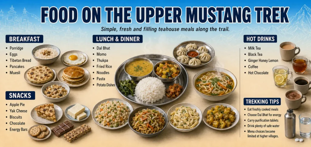
Food on the Upper Mustang Trek is centred on the standard Nepalese trekking menu — dal bhat (lentil soup and rice, served with vegetable curry and achaar), momos (dumplings, either steamed or fried), noodle soups, tsampa porridge, buckwheat pancakes, and boiled or fried potatoes. The local buckwheat products — pancakes, noodles, and a dense flat bread called dhero — are distinctive Upper Mustang specialities that are worth trying. The grain-based staples reflect the agriculture of the plateau. Meat is available (yak and mountain goat, locally) but quality control is difficult to verify at altitude; our guides advise sticking to vegetarian options in smaller villages. Tea, butter tea (a Tibetan staple made with yak butter and salt, an acquired taste), and hot lemon water are the standard beverages. Bottled water is expensive and environmentally problematic at this altitude — water purification tablets or a filter bottle are strongly recommended.
Upper Mustang vs Lower Mustang — What’s the Difference?
Lower Mustang refers to the section of the Mustang district south of the checkpoint at Kagbeni — the Kali Gandaki valley towns of Marpha, Tukuche, Larjung, and Kagbeni itself, as well as Jomsom. This area does not require a restricted-area permit and is accessible on any standard Annapurna Conservation Area Permit. It is a popular destination in its own right, particularly Marpha (famous for its apple orchards and apple brandy) and Kagbeni (a photogenic walled village that marks the boundary of the restricted zone). However, Lower Mustang is entirely different in character from Upper Mustang — it is greener, more visited, more connected to the mainstream Nepal trekking infrastructure, and entirely lacking the extraordinary Tibetan cultural landscape and remote terrain that define the Upper Mustang experience. For trekkers who have been to Lower Mustang and wonder whether Upper Mustang is worth the additional permit cost: the answer is unequivocally yes. The restricted-area permit is what has preserved Upper Mustang’s extraordinary character, and the experience of Lo Manthang, Chhoser, and the high plateau bears no resemblance to anything in Lower Mustang.
Why Trek Upper Mustang with Next Trip Nepal?
Next Trip Nepal is a Kathmandu-based trekking agency staffed by Nepalese mountaineers, guides, and logistics specialists with decades of combined experience in Upper Mustang. Our guides are licensed by the Nepal Tourism Board, fluent in English, and — crucially — have personal relationships with the monastery caretakers, village elders, and community leaders in Lo Manthang and the villages along the route. These relationships translate directly into better access, richer cultural insight, and a more authentic experience for our guests. We handle all permits (UMAP, ACAP, TIMS) in advance so you arrive ready to trek. We manage domestic flights, ground transport, teahouse bookings, and porter arrangements. Our group sizes are small (maximum 12 trekkers per group) to minimise impact on the fragile ecology and cultural environment of the restricted zone. And our pricing is transparent — the per-person cost listed on this page includes the full USD 500 UMAP, all accommodation and meals on trek, all transport, and the guide and porter package. There are no hidden extras beyond the items listed in the cost excludes section.
Best Time to Trek Upper Mustang: Month by Month
Weather and the trail change a lot across the year in this rain shadow region. Read the guide for the month you are planning around: January, February, March, April, May, June, July, August, September, October, November, December.
Trip Highlights
- Stand inside Lo Manthang, a medieval walled city founded in 1380 that remains Nepal's best-preserved Tibetan Buddhist kingdom — home to four ancient gompas, a 600-year-old royal palace, and a living community of Lo-pa people whose culture, language, and daily life have changed little in centuries
- Explore the Chhoser sky caves — thousands of man-made chambers carved into towering cliff faces at vertiginous heights, some over 2,500 years old, yielding archaeological finds that have rewritten the early history of the Himalayan plateau and featured in National Geographic
- Trek through Upper Mustang's rain-shadow desert — a landscape of deep red iron-oxide cliffs, ochre canyon walls, and wind-carved badlands entirely unlike any other trekking destination in Nepal, more reminiscent of the American Southwest or the Tibetan plateau than the green Himalayas
- Walk the ancient Tibetan salt-trade route along the Kali Gandaki, the world's deepest river gorge, flanked by Annapurna I (8,091 m) and Dhaulagiri (8,167 m) — a corridor used by traders for at least two thousand years and one of the great natural spectacles of Asia
- See the 14th-century murals of Thubchen Gompa in Lo Manthang — among the finest surviving examples of classical Tibetan Buddhist wall painting in existence, recently restored with support from the American Himalayan Foundation and comparable to the great mural traditions of Ladakh and Bhutan
- Visit Ghar Gompa (Nyphu Gompa), one of the oldest Buddhist monasteries in Nepal, perched on a clifftop above a roaring canyon near Ghami, traditionally credited to Guru Rinpoche and believed to date to the 8th century CE
- Cross Nyi La Pass (4,010 m) on a half-day excursion from Lo Manthang, with panoramic views across the Tibetan plateau and down into the sculpted canyons of the upper Mustang highlands — one of the most memorable viewpoints on any Nepal trekking route
- Trek Upper Mustang during the monsoon season (June–September) when the rest of Nepal is wet and cloudy — the Himalayan rain shadow keeps the plateau dry, clear, and accessible year-round, making this Nepal's premier monsoon trekking destination
- Benefit from the March 2026 rule change: Upper Mustang now permits solo trekking for the first time in its 34-year history as a restricted zone, meaning single travellers can book without needing a partner — though a licensed guide remains legally mandatory
- Experience the full depth of living Tibetan Buddhist culture — prayer flags snapping over chortens, monks debating in monastery courtyards, women in traditional chubas grinding tsampa at hand mills, and the scent of juniper incense drifting through the narrow lanes of a city whose rhythms have not changed in six centuries
- See the Tiji Festival (Tenchi) if timing allows — three days of elaborate masked cham dance performed by Choede Gompa monks in Lo Manthang's main courtyard, the most spectacular religious festival in Upper Mustang's calendar, held annually in late May
- Collect or observe saligrams — sacred ammonite fossils embedded in the Kali Gandaki riverbed, believed in Hinduism to be direct manifestations of Vishnu, and physical evidence that this entire landscape was once the floor of an ancient sea before the Himalayas rose
Write a Review
You must be logged in to post a comment.