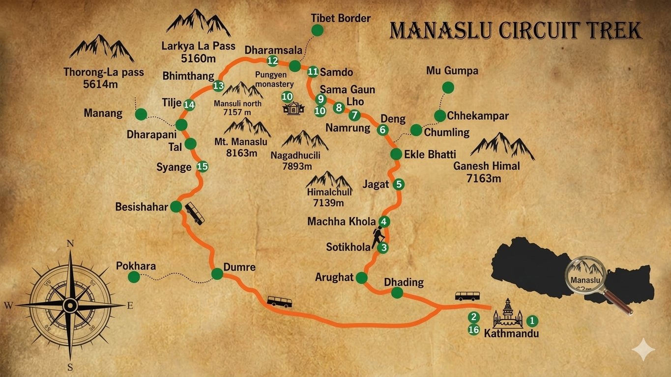
Understanding the Manaslu Circuit Trek map helps trekkers visualize exactly how this route loops around Mount Manaslu, from the low lying Budhi Gandaki river valley through increasingly high altitude Tibetan influenced villages before crossing Larkya La Pass and descending into the Annapurna region near Besisahar. This guide walks through the route’s geography in detail, covers every major waypoint and its elevation, and explains how to get and use an actual trekking map for this specific trail, whether you are planning your trip or simply trying to understand the route’s overall shape before booking.
The short answer: the Manaslu Circuit Trek map traces a roughly horseshoe shaped route beginning at Machha Khola in the south, following the Budhi Gandaki river north through the Manaslu Conservation Area, curving east and then west around the base of Mount Manaslu itself, crossing Larkya La Pass at 5,106 meters, and descending south again through Bimthang and Tilije to Besisahar, covering approximately 177 kilometers of trail across the standard 13 day itinerary.
Manaslu Circuit Trek Map Overview
| Factor | Detail |
|---|---|
| Total Trail Distance | Approximately 177 kilometers |
| Starting Point | Machha Khola, southern edge of the route |
| Highest Point | Larkya La Pass, 5,106 meters, northeastern section of the loop |
| Ending Point | Besisahar, southern edge of the Annapurna region |
| Route Shape | Horseshoe loop around the western and northern flanks of Manaslu |
| River Followed | Budhi Gandaki, then Dudh Khola near Samagaon |
Understanding the Route’s Overall Shape
The Manaslu Circuit Trek map shows a route that does not circle Manaslu in a perfect loop but rather traces its western and northern flanks before crossing to the eastern side of the Marsyangdi watershed via Larkya La Pass. This means the trek genuinely feels like a journey from one river valley system into another, rather than a simple circular walk, with the Budhi Gandaki carrying trekkers north through the trek’s first week before Larkya La Pass serves as the geographic hinge connecting this valley to the Marsyangdi system that eventually leads to Besisahar. Understanding this shape helps explain why the trek’s difficulty genuinely concentrates around the pass crossing itself, since this is the single point where the route transitions between two entirely separate river systems.
Key Waypoints on the Manaslu Circuit Map
| Waypoint | Elevation | Position on the Route |
|---|---|---|
| Machha Khola | 900 meters | Starting point, southern edge |
| Jagat | 1,340 meters | Permit checkpoint, early southern section |
| Deng | 1,860 meters | Lower middle section |
| Namrung | 2,660 meters | Middle section, second permit checkpoint |
| Shyala | 3,180 meters | Upper middle section, first close Manaslu views |
| Samagaon | 3,500 meters | Largest upper village, acclimatization stop |
| Samdo | 3,875 meters | Final significant village before the pass |
| Dharamsala | 4,450 meters | Final staging point before Larkya La Pass |
| Larkya La Pass | 5,106 meters | Highest point, geographic hinge of the route |
| Bimthang | 3,590 meters | First stop beyond the pass, Annapurna side |
| Tilije | 2,535 meters | Lower Annapurna region section |
| Besisahar | 760 meters | Ending point, road connection to Kathmandu |
The Route’s Elevation Profile Explained
Reading the Manaslu Circuit Trek map alongside its elevation profile reveals a genuinely gradual climb through the route’s first week, rising from 900 meters at Machha Khola to around 3,500 meters at Samagaon across roughly six days of trekking, followed by a more concentrated altitude gain across the final approach to Larkya La Pass, and then a rapid, dramatic descent of over 1,500 meters in a single day down to Bimthang. This elevation profile, considerably more gradual in its first half than its second, is precisely why the itinerary includes its dedicated acclimatization day at Samagaon rather than earlier in the route, since this is the point where the map shows the trail’s character genuinely shifting from valley walking to high altitude mountain trekking.
Geographic Regions the Map Passes Through
The Manaslu Circuit Trek map crosses through several genuinely distinct geographic and cultural zones as it progresses north and then east around Manaslu. The southern section, from Machha Khola through Jagat, sits within subtropical lowland Nepal, with terraced farmland and Gurung and Tamang villages typical of the country’s mid hill regions. The middle section, from Deng through Samagaon, enters the Manaslu Conservation Area’s more sensitive interior, where Tibetan Buddhist cultural influence becomes increasingly dominant. The northern section, from Samdo through Larkya La Pass, sits within a genuinely high altitude trans Himalayan zone, arid and sparsely vegetated, before the map’s final section beyond the pass reenters the more forested, Gurung influenced Annapurna region on the descent toward Besisahar.
Rivers and Water Features Shown on the Map
The Budhi Gandaki river dominates the map’s southern and middle sections, with the trail following its course closely and crossing it repeatedly via suspension bridges between Machha Khola and Namrung. Beyond Namrung, the route follows a tributary valley toward Samagaon, where the Dudh Khola, fed by glacial meltwater from Manaslu itself, becomes the dominant water feature, with Birendra Lake, a glacial lake just above Samagaon, appearing as a notable side feature on any detailed trekking map of this section. Beyond Larkya La Pass, the map shows the route following drainage down toward the Dudh Khola on the Annapurna side before eventually joining the larger Marsyangdi river system near Besisahar.
Mountains Visible Along the Route
The Manaslu Circuit Trek map sits within view of several major Himalayan peaks beyond Manaslu itself, and understanding which mountains are visible from which sections helps trekkers know what to look for at each stage. Manaslu, at 8,163 meters, dominates the skyline from Shyala through Samdo, while Himlung Himal and Cheo Himal become visible specifically from the Larkya La Pass crossing itself, with Annapurna II and Ganesh Himal also appearing on clear days from various points along the route’s northern and eastern sections. Bimthang, just beyond the pass, offers one of the map’s most celebrated viewpoints, with Manaslu visible behind the trekker while the Annapurna range opens up ahead.
How to Get a Physical or Digital Manaslu Circuit Trek Map
Trekkers can obtain a Manaslu Circuit Trek map through several channels, including physical topographic maps available from bookshops in Kathmandu’s Thamel district, digital GPS tracks available through trekking specific apps, and the detailed route map Next Trip Nepal provides to every trekker as part of the standard booking package. We genuinely recommend carrying both a physical map as a reliable backup and a digital GPS tracking app on your phone, since digital tools depend on battery life and device reliability that a paper map does not, particularly important given how limited charging opportunities become in the route’s more remote upper sections.
Using GPS Apps Alongside the Physical Map
Several offline capable GPS and mapping apps, downloaded and cached before departure given the route’s limited connectivity, work well for tracking progress along the Manaslu Circuit. These apps typically show your real time position against the trail, useful both for general orientation and as a safety backup should visibility become poor, particularly relevant around Larkya La Pass where cloud and snow can occasionally reduce visibility significantly. Your guide will carry their own GPS device and detailed knowledge of the route regardless, but many trekkers still find genuine value in following their own progress on a personal device throughout the trek.
Frequently Asked Questions About the Manaslu Circuit Map
How long is the Manaslu Circuit Trek route in total distance?
The standard route covers approximately 177 kilometers from Machha Khola to Besisahar, though this figure varies slightly depending on the exact itinerary and any side trips taken along the way.
Where can I buy a physical map of this route?
Trekking specific bookshops in Kathmandu’s Thamel district sell detailed topographic maps covering the Manaslu region, and Next Trip Nepal also provides a route map as part of every standard booking.
Does the map show the Tsum Valley extension route?
Yes, detailed Manaslu region maps typically show the Tsum Valley side route branching off near Philim, useful for trekkers considering this extension alongside the standard circuit.
Is mobile signal reliable enough to rely on digital maps throughout the route?
No, mobile signal becomes unreliable beyond Namrung and essentially disappears from Samdo through the pass crossing, which is precisely why offline capable mapping apps, downloaded before departure, matter more than apps requiring live signal.
How accurate are online elevation figures for this route?
Elevation figures can vary slightly between different maps and sources, typically by twenty to thirty meters at any given point, reflecting differences in measurement methods rather than any genuine inconsistency in the route itself.
Comparing the Manaslu Circuit Map to Other Nepal Trekking Routes
| Factor | Manaslu Circuit | Everest Base Camp | Annapurna Circuit |
|---|---|---|---|
| Total Distance | Approximately 177 km | Approximately 130 km round trip | Approximately 160 to 230 km |
| Route Shape | Horseshoe loop, one direction | Out and back | Full circuit loop |
| Starting and Ending Points | Different, Machha Khola to Besisahar | Same, Lukla both ways | Different or same depending on variant |
This comparison highlights a genuinely distinctive feature of the Manaslu Circuit map compared to Nepal’s other major trekking routes: unlike Everest Base Camp’s out and back structure, Manaslu Circuit moves continuously in one direction from a southern starting point to a different ending point further east, meaning trekkers never retrace their own steps, a quality that many find adds genuine variety to the overall trekking experience.
Side Trails and Alternate Routes Shown on Detailed Maps
Beyond the main trekking route, detailed Manaslu Circuit maps show several worthwhile side trails, including the path toward Manaslu Base Camp from Samagaon, the route to Pungyen Monastery, and the Tsum Valley branch near Philim. Trekkers with additional time should discuss these options with their guide, since a detailed map alone does not convey which side trails are genuinely worth the additional time and effort versus those better skipped given typical energy levels at that stage of the trek.
Understanding Contour Lines on the Route’s Steepest Sections
Trekkers examining a detailed topographic map of this route will notice contour lines bunching tightly together at a few specific points, most notably the climb from Deng to Namrung and the final approach to Larkya La Pass itself, both indicating genuinely steep, sustained elevation gain. Understanding these sections in advance through the map helps trekkers mentally prepare for the specific days that will feel most demanding, rather than being caught off guard by a section that the itinerary table alone might not fully convey.
How the Route Map Relates to Permit Checkpoints
The Manaslu Circuit Trek map includes two formal permit checkpoints, at Jagat and again at Namrung, where officials verify the Manaslu Restricted Area Permit and Manaslu Conservation Area Project permit before trekkers continue further into the region. A third checkpoint near Dharapani, on the Annapurna side beyond the pass, verifies the Annapurna Conservation Area Permit covering the route’s final days. For full details on what these permits cost and how they work, see our Nepal Trekking Permits guide.
Weather Zones Reflected in the Route’s Geography
The map’s dramatic elevation and geographic range across the route means trekkers pass through genuinely distinct weather zones within a single trek, from the humid subtropical conditions near Machha Khola through increasingly cold and dry high altitude terrain approaching Larkya La Pass, before descending back into the more temperate, forested Annapurna side. Understanding this progression through the map helps trekkers pack appropriately for each stage rather than assuming uniform conditions throughout the entire route.
Villages and Settlements Along the Mapped Route
Beyond the major overnight stops listed in the waypoint table above, the Manaslu Circuit map shows numerous smaller settlements along the way, including Khorlabesi, Tatopani, Philim, and Lho, each offering brief rest stops, tea houses, or points of cultural interest even when not used as formal overnight stays. These smaller waypoints help break the longer trekking days into more manageable segments and often provide welcome opportunities for a short break or a look at local life along the trail.
Using the Map to Plan Rest Days and Extensions
A detailed map genuinely helps trekkers visualize exactly where extra rest days or extensions make the most sense, whether that means an additional acclimatization day at Samagaon, positioned at the map’s critical altitude transition point, or a Tsum Valley extension branching off near Philim in the route’s lower section. Trekkers planning these adjustments should discuss them with Next Trip Nepal well before departure, since the map shows clearly how these extensions affect the overall route logistics and permit requirements.
Why Understanding the Map Matters Before Booking
Genuinely understanding the Manaslu Circuit Trek map before booking helps trekkers set realistic expectations for what each day of the itinerary actually involves, beyond simply reading distance and elevation figures in a table. Seeing how the route moves through distinct geographic zones, crosses between two separate river systems via Larkya La Pass, and connects villages with genuinely different cultural characters gives trekkers a much richer sense of the journey ahead than statistics alone can convey.
Booking Your Manaslu Circuit Trek With the Full Route Map
Next Trip Nepal provides every trekker with a detailed route map as part of the standard booking package, alongside the full itinerary and permit arrangements this trek requires. For complete pricing, what is included, and our step by step booking process, see our Manaslu Circuit Trek booking guide, or our detailed day by day itinerary guide for a closer look at what each stage of this mapped route actually involves.
Elevation Gain Statistics by Map Section
Breaking the mapped route into its component sections shows just how unevenly elevation gain is distributed across the trek, a detail that becomes obvious on the map but is easy to miss when only reading a day by day distance table. The opening section from Machha Khola to Namrung climbs a genuinely gradual 1,760 meters spread across four full trekking days, an average pace that feels comfortable even to trekkers without extensive prior high altitude experience. The middle section from Namrung to Samagaon adds another 840 meters over two shorter days, a noticeably steeper average gain per day that begins to test acclimatization for the first time. The most demanding section by far, from Samagaon to the top of Larkya La Pass, climbs 1,606 meters across roughly four days including the dedicated rest day at Samagaon, concentrating the bulk of the route’s total elevation gain into its final push. Understanding this uneven distribution, visible immediately on any properly contoured map of the route, explains why the itinerary slows down so deliberately in its final third even though the map’s visual scale can make the whole route look evenly paced at first glance.
How Map Scale Affects Trip Planning
Trekkers studying a Manaslu Circuit Trek map for the first time often underestimate how much genuine distance separates points that appear close together on a small scale printed map, particularly across the route’s winding sections through the Budhi Gandaki gorge where the trail switches back repeatedly to follow the river’s course. A map printed at a larger scale, typically 1 to 50,000 or similar, shows this winding character far more clearly than a small overview map compressed onto a single page, and is genuinely worth seeking out specifically for the days between Machha Khola and Namrung where the trail’s actual walking distance considerably exceeds the straight line distance a smaller scale map might suggest. Digital mapping tools that allow zooming into specific sections solve this problem more elegantly than any single printed sheet, which is one reason most trekkers now carry both a general overview map for context and a GPS enabled device or app for the detailed, real time picture of exactly where the trail goes next.
Comparing Trail Visibility Across Different Map Sources
Not every Manaslu Circuit Trek map available online or in print shows the same level of trail detail, and trekkers researching their route in advance should understand these differences before relying too heavily on any single source. Official Nepal government topographic sheets offer genuinely accurate elevation contours but were not specifically designed for trekking and can lack clear trail markings in more remote sections. Dedicated trekking maps produced by specialist publishers generally show the trail itself far more clearly, along with teahouse locations and estimated walking times between major points, making them considerably more practical for day to day navigation than a general topographic sheet alone. Crowd sourced digital mapping platforms, built from GPS tracks submitted by previous trekkers, often provide the most current and granular trail visibility of any source, particularly useful given how trail routing can shift slightly year to year in response to landslides, bridge repairs, or seasonal river crossings, though these platforms work best as a supplement to a proper printed map rather than a complete replacement for one.
Reading the Map’s Cultural and Religious Waypoints
Beyond pure geography, a detailed Manaslu Circuit Trek map typically marks numerous monasteries, chortens, and mani walls scattered along the route, particularly concentrated through the trek’s upper Tibetan influenced sections around Lho, Samagaon, and Samdo. These markings are not merely decorative additions to the map, and understanding their location in advance helps trekkers recognize and appropriately respect these sites when passing through, including the customary practice of walking clockwise around mani walls and chortens rather than cutting directly through or around them in the opposite direction. The map’s marking of Pungyen Monastery near Samagaon in particular flags a genuinely worthwhile side visit for trekkers using their acclimatization day there, a detail easily missed without a map that specifically calls out these cultural waypoints alongside the purely geographic ones.
Map Based Emergency and Evacuation Planning
A properly detailed route map also plays a genuinely practical role in emergency planning, showing trekkers and guides alike exactly which sections of the route sit within realistic reach of helicopter evacuation versus which stretches would require either a lengthy walk out or a wait for improved weather before any airlift becomes possible. The map shows clearly how the route’s most remote section, between Samdo and Bimthang across Larkya La Pass, sits furthest from any road access point, reinforcing why proper acclimatization and honest self assessment of symptoms matter most precisely in this stretch of the trek. Reputable operators including Next Trip Nepal build this map based understanding directly into guide training, ensuring that in the rare event of a genuine emergency, decisions about whether to descend, wait, or call for evacuation are made with a clear practical understanding of exactly where on the route the group currently stands.
Digital Map Tools Worth Considering Before Departure
Several dedicated offline mapping applications now offer downloadable Manaslu Circuit Trek routes, allowing trekkers to track their exact position against the trail even without any mobile signal, a genuinely valuable backup to the physical map and guide knowledge that traditionally formed the sole basis for route finding on this trek. These apps work by downloading map tiles and GPS track data in advance, typically over hotel wifi in Kathmandu before departure, then using the device’s GPS chip alone to show real time position without requiring any cellular or data connection along the trail itself. While Next Trip Nepal’s experienced guides make personal navigation tools genuinely unnecessary for safe route finding, many trekkers still enjoy carrying one of these apps simply for the added engagement of watching their progress against the map in real time, and as a reassuring backup during the trek’s more remote and poorly signed sections.
Seasonal Variations Visible on the Map
The route shown on any standard Manaslu Circuit Trek map stays fixed year round, but the actual walking conditions across that same mapped route shift considerably by season in ways worth understanding before choosing departure dates. Snow cover extends noticeably lower down the mapped route during winter months, sometimes closing sections of the trail approaching Larkya La Pass entirely, while the monsoon season transforms the lower river gorge sections shown on the map into a considerably wetter and more leech prone environment despite the trail itself following an unchanged path. Spring departures see the mapped route’s lower and middle sections framed by blooming rhododendron forest, while autumn generally offers the clearest visibility for appreciating the mapped route’s mountain views, particularly across the dramatic stretch between Samagaon and the pass itself where Manaslu dominates the skyline on clear days.
How the Map Reflects Water Sources for Trekkers
A genuinely useful route map for this trek also marks the location of reliable water sources along each day’s walking, a practical detail that matters considerably more once the trail climbs above Samagaon where teahouse spacing becomes noticeably sparser than in the lower valley. Below Namrung, the trail runs close enough to the Budhi Gandaki and its tributaries that water access rarely poses any planning concern, but the stretch from Samdo through Dharamsala to the pass itself requires slightly more deliberate planning, since natural water sources become less frequent and more seasonal the higher the route climbs. Guides carry this knowledge as a matter of routine experience, but trekkers who study the map in advance gain a clearer sense of why certain stops, Dharamsala in particular, exist precisely where they do rather than at a more evenly spaced interval along the route.
Map Landmarks That Signal Altitude Milestones
Certain points marked on any detailed Manaslu Circuit Trek map function as genuinely useful psychological and physical milestones for trekkers tracking their own progress through the itinerary’s demanding middle and final sections. The tree line, generally falling somewhere between Namrung and Lho depending on exact local conditions, marks a visible shift on the map and on the ground alike, as the landscape opens from forest into the exposed high valley terrain that characterizes the trek’s upper reaches. Birendra Lake above Samagaon marks another commonly referenced landmark, sitting close enough to the main route for an easy side visit during the acclimatization day, and its position on the map helps trekkers gauge roughly how much additional walking a detour there would involve. The final approach to Larkya La Pass itself, visible on the map as the point where the trail’s contour lines bunch most tightly together, represents the clearest and most anticipated milestone of the entire mapped route.
Using the Map to Understand Guide and Porter Logistics
The route map also helps explain the practical logistics behind how Next Trip Nepal staffs and supplies each trek, since porter and guide arrangements shift somewhat depending on which stretch of the mapped route a group currently occupies. Below Namrung, where the trail remains within a day’s walk of road access at multiple points, resupply logistics stay relatively straightforward. Above Samagaon, where the map shows the route moving increasingly far from any vehicle access, porters and kitchen staff must carry supplies considerably further between resupply points, a logistical reality that shapes menu variety at the higher teahouses discussed elsewhere in our trek planning content. Understanding this map based logistical picture helps explain some of the practical differences trekkers notice between the trek’s lower and upper sections, beyond simply the more obvious changes in altitude and scenery.
How the Map Illustrates the Trek’s Restricted Area Status
The Manaslu Circuit’s continued classification as a restricted area, requiring a special permit and guided travel rather than independent trekking, is itself a detail closely tied to the route’s mapped geography, since the trail runs close to the Tibet border for a meaningful stretch of its middle and upper sections. Samdo in particular sits near enough to this border that its position on the map explains much of the additional permit oversight this trek requires compared to more open routes elsewhere in Nepal. This border proximity, clearly visible on any properly detailed map of the region, is part of what has kept the Manaslu Circuit considerably quieter than comparable circuit treks elsewhere in the country, preserving a genuinely more remote trekking experience for those who book this specific route.
Common Map Reading Mistakes Trekkers Make
A handful of map reading mistakes recur often enough among trekkers planning this trek that they are worth flagging directly. Judging the difficulty of a day purely from horizontal distance on the map, without paying close attention to the elevation contours layered beneath the trail line, leads some trekkers to underestimate days like Deng to Namrung that cover modest distance but involve genuinely sustained climbing. Assuming the trail follows the most direct visible line between two points on a small scale map is another common error, when in practice the actual trail frequently switches back repeatedly to manage grade, particularly through the steeper gorge sections in the trek’s early days. Relying entirely on a single digital mapping source without a printed backup is a third mistake worth avoiding, since battery life and device reliability cannot always be guaranteed across a two week trek through terrain with limited charging opportunities beyond Samagaon.
Why a Guide’s Local Knowledge Still Matters Alongside Any Map
However detailed a Manaslu Circuit Trek map might be, it cannot fully replace the accumulated local knowledge an experienced guide brings to the route, particularly regarding current trail conditions that shift from season to season and year to year in ways no static map can reflect. A guide knows which suspension bridges have recently been repaired or rerouted, which sections currently carry landslide risk after heavy rain, and which teahouses along the mapped route are open in any given season, details that go well beyond what even the most current digital map can capture. Next Trip Nepal’s guides combine this genuine local knowledge with the kind of detailed map understanding covered throughout this guide, giving trekkers the benefit of both accurate route visualization before departure and real time, ground level judgment throughout the trek itself.
Printing and Carrying a Physical Map on Trek
Despite the genuine usefulness of digital mapping tools, many experienced trekkers still recommend carrying a printed physical map as a reliable backup that requires no battery and cannot fail from a software glitch or a dropped signal. A waterproof or laminated printed map, folded to a manageable size, adds negligible weight to a pack while providing a genuinely dependable reference throughout the trek, particularly valuable during the pass crossing itself when cold temperatures can meaningfully shorten battery life on any electronic device carried along. Trekkers booking with Next Trip Nepal receive route information as part of the standard pre departure briefing, and we are happy to discuss specific physical map recommendations for trekkers who prefer this traditional backup alongside whatever digital tools they also choose to bring.
Related Manaslu Circuit Guides
- Manaslu Circuit Trek Itinerary: 10 to 22 Day Route Guide
- Manaslu Circuit Trek Difficulty: What to Really Expect
- Solo Manaslu Circuit Trek: Permits, Costs, and Booking
- Manaslu Circuit Trek Booking Guide
Final Word on the Manaslu Circuit Trek Map
The Manaslu Circuit Trek map reveals a genuinely well designed route, tracing a natural geographic path around Manaslu’s western and northern flanks before crossing into an entirely different river system via Larkya La Pass and descending toward Besisahar. Understanding this route’s actual shape, elevation profile, and the distinct geographic zones it passes through gives trekkers a considerably richer appreciation for the journey than a simple itinerary table alone can provide, and helps set realistic expectations for exactly what each stage of this remarkable trans Himalayan trek genuinely involves. Trekkers who take the time to study the route map before departure consistently arrive better prepared, both mentally and logistically, for a trek that rewards genuine understanding of its geography with a correspondingly deeper appreciation for the landscape it moves through.