6 Day Annapurna Base Camp Trek 2026: Direct Route from Pokhara

6 Days
Trek at a Glance
Duration6 days (Pokhara to Pokhara)
Max Altitude4,130m / 13,549ft (Annapurna Base Camp)
Start and End PointPokhara
DifficultyModerate to challenging
RouteDirect: Jhinu Danda, Chhomrong, Dovan, Deurali, ABC
Best SeasonMarch to May, September to November
Permits RequiredACAP (NPR 3,000) and TIMS Card (NPR 1,000)
AccommodationTeahouses throughout
MealsThree meals daily included on trek

The 6 Day Annapurna Base Camp Trek is the most direct route to ABC, starting and finishing in Pokhara without any side detours. The trail goes straight into the Modi Khola valley from day one, following the river upstream through the Gurung and Magar villages of Jhinu Danda and Chhomrong before entering the Annapurna Sanctuary at Dovan and climbing to Annapurna Base Camp at 4,130 metres. The return follows the same trail down, with the natural hot springs at Jhinu Danda on the final day before the drive back to Pokhara. Six days, one route, one goal.

This is the route we recommend for trekkers with limited time who want the full ABC experience without any detour. The total walking distance is approximately 55 to 60 kilometers over five trekking days. The altitude profile is straightforward: you gain height steadily each day from Jhinu Danda at 1,780 meters to ABC at 4,130 meters, with one acclimatization stop at Deurali (3,230m) before the final climb. The return on day six is a long descent from ABC back to Jhinu Danda in one day, with a vehicle waiting to take you to Pokhara the same evening.

The Trail: Jhinu Danda to Annapurna Base Camp

Jhinu Danda (1,780m): The Entry Point

The drive from Pokhara to New Bridge (Syauli Bazaar, 1,340m) takes 1 hour 45 minutes. From New Bridge the trail follows the Modi Khola upstream for 2 to 3 hours to Jhinu Danda at 1,780 metres. Jhinu is a small Gurung settlement with several teahouses above the river. The natural hot springs sit below the village at river level: most trekkers skip these on day one and use them on day six on the return, when the legs need them most.

Chhomrong (2,170m): Last Village Before the Sanctuary

Chhomrong is a large Gurung village at 2,170 metres with the best teahouse facilities on the entire ABC route. It has a working ATM, strong mobile signal, attached bathroom rooms, reliable hot showers and a full range of food. This is the last place with these facilities before you enter the Annapurna Sanctuary. Above Chhomrong, rooms are smaller, bathrooms are shared and hot showers cost extra. Chhomrong is also the key permit checkpoint. The village sits on a ridge with direct views of Annapurna South (7,219m) and Hiunchuli (6,441m) across the valley. Day two from Jhinu to Chhomrong is intentionally short at 2 to 3 hours to allow an acclimatisation afternoon before the harder days ahead.

Chhomrong to Dovan (2,580m): Into the Gorge

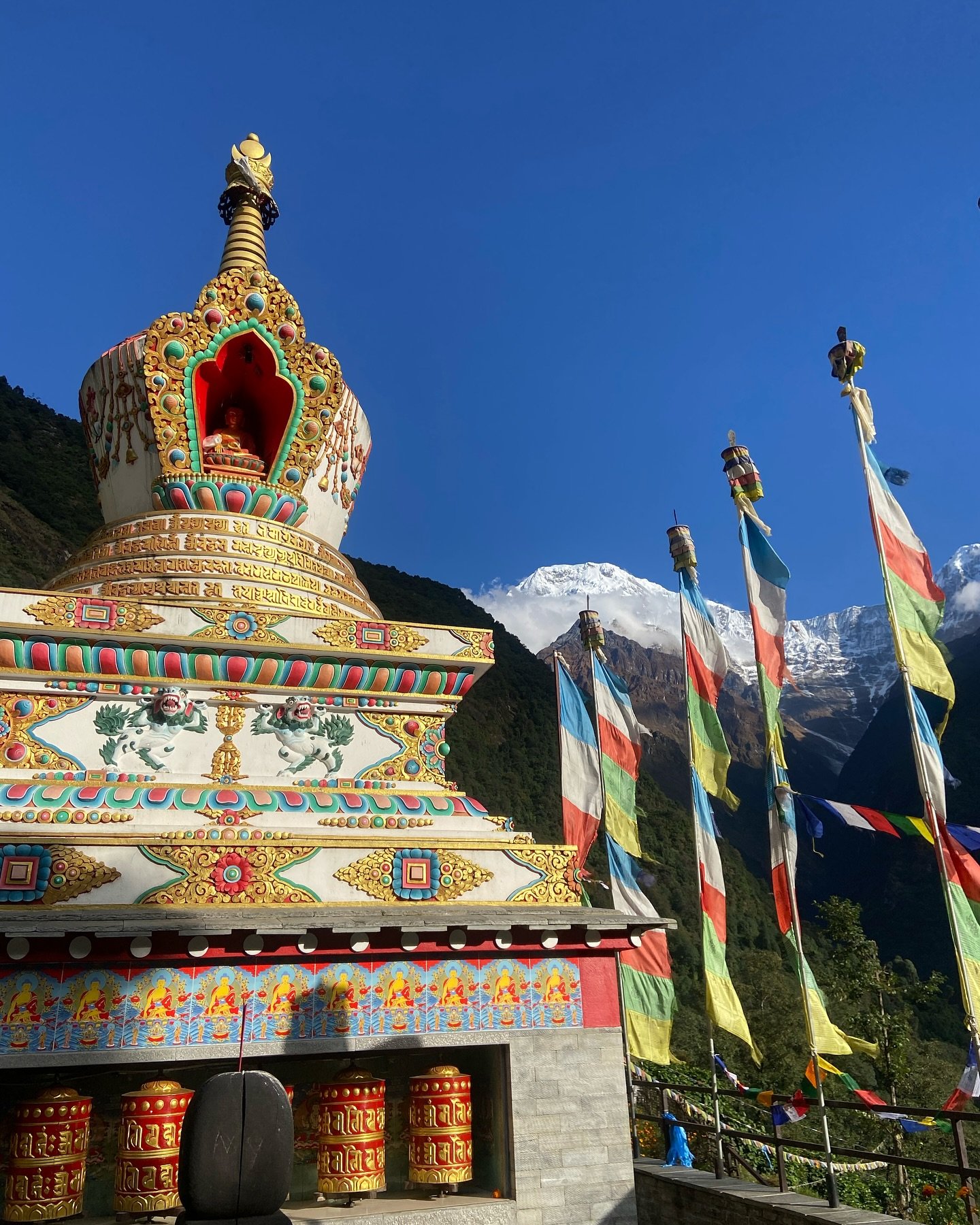
From Chhomrong the trail drops steeply to the river and immediately climbs to Sinuwa (2,360m). This descent and re-ascent pattern repeats through the gorge. From Sinuwa the trail enters dense bamboo and rhododendron forest through Bamboo camp (2,310m) and rises to Dovan at 2,580 metres, where the valley narrows and the forest begins to thin above. Day three takes 5 to 6 hours with consistent but not extreme gradient changes.

Dovan to Deurali (3,230m): Entering Alpine Zone

Above Dovan the forest gives way to scrub vegetation and then open alpine terrain. The trail passes Himalaya Hotel (2,920m) at the treeline, then Hinku Cave (2,970m), a large rock overhang shelter, before reaching Deurali (3,230m). At Deurali the Sanctuary entrance becomes visible for the first time. This is the acclimatisation stop: a night at 3,230 metres before the 900-metre push to ABC on day five. Your guide checks oxygen saturation here with the pulse oximeter. This stop is important and should not be skipped.

Deurali to Annapurna Base Camp (4,130m) via MBC (3,700m)

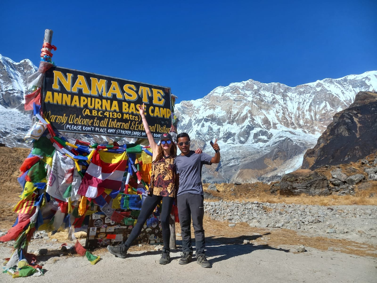
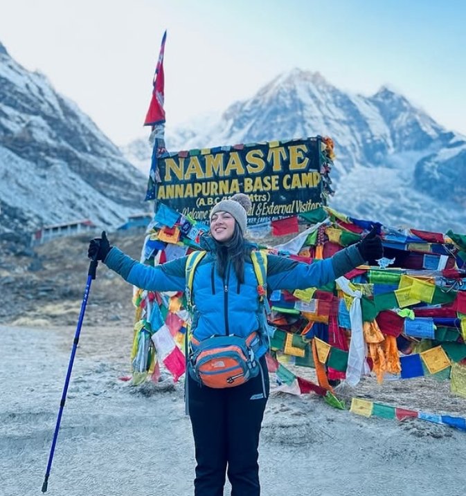
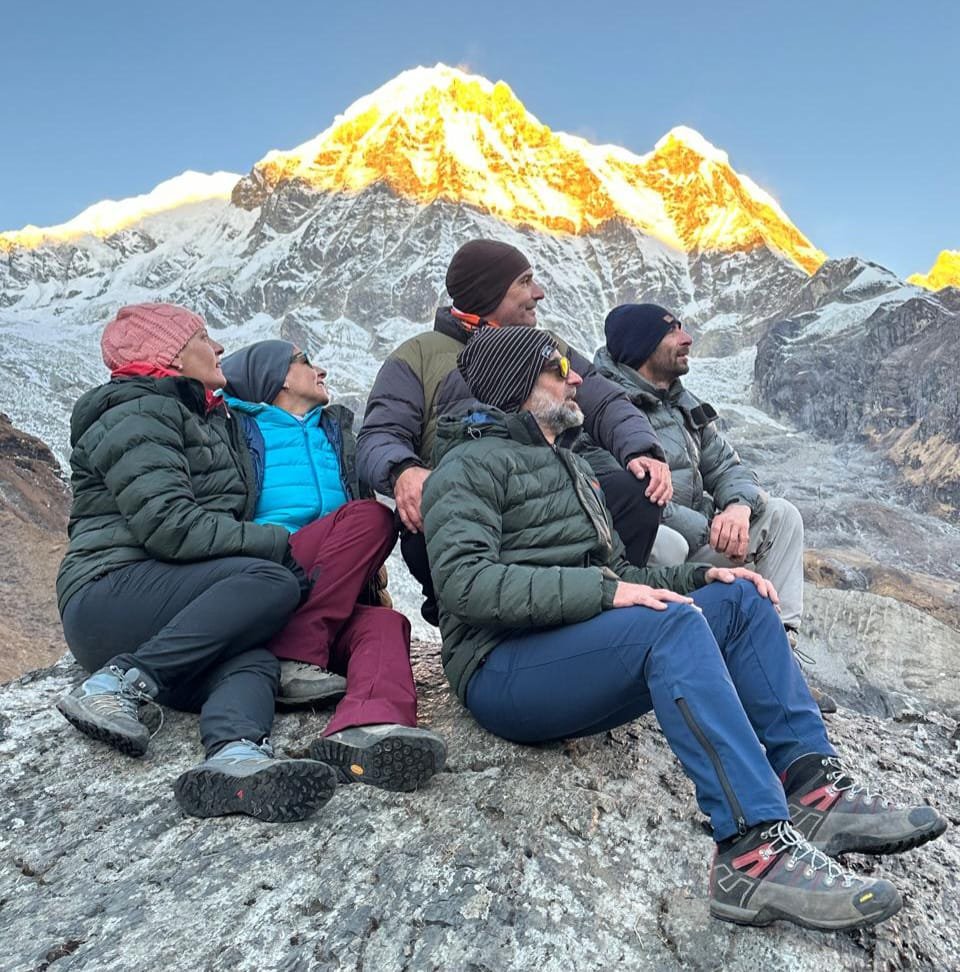
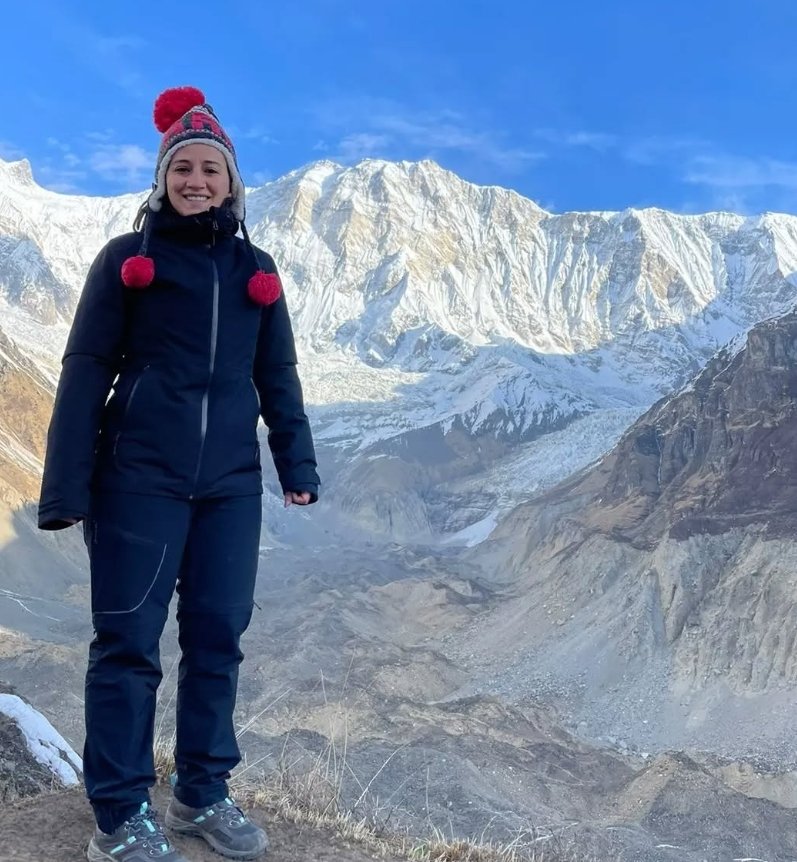
The goal of the trek. From Deurali the trail crosses into the Sanctuary fully on glacial moraine with Machapuchare (6,993m) directly ahead. Machapuchare Base Camp (MBC, 3,700m) is reached in 2.5 to 3 hours: a cluster of teahouses on a flat area under the Fishtail peak. Rest and check oxygen here before the final 1.5 to 2 hour push to ABC. At Annapurna Base Camp (4,130m) the full ring of peaks closes around you: Annapurna I (8,091m) to the north, Annapurna South (7,219m) and Hiunchuli (6,441m) to the south and southwest, Gangapurna (7,455m) and Glacier Dome (7,193m) to the northeast, Annapurna III (7,555m) to the east. You are not looking at the mountains from outside: you are standing inside the mountain ring.

Machapuchare has never been summited. The Nepal government closed it to climbing out of respect for its religious significance to the Gurung people. It is the most recognised peak in the Annapurna range and the one you walk toward for the entire upper section of the trail.

ABC to Dovan and Jhinu Danda: The Long Descent (Day 6)

Early start from ABC at 5:30 to 6:00 AM. The trail descends through MBC and Deurali back through the alpine zone to Dovan, then continues through Bamboo and Sinuwa past Chhomrong to Jhinu Danda (1,780m). Total descent: approximately 2,350 metres over 7 to 8 hours. Trekking poles reduce the knee load significantly on this day. At Jhinu Danda, the hot springs at river level cost NPR 200 to 300 per person. Spend 45 minutes to an hour in the pools before the short walk to New Bridge, where your vehicle drives you back to Pokhara in 1 hour 45 minutes.

Altitude and Acclimatisation

The direct route manages acclimatisation through pacing: a short day two (Jhinu to Chhomrong, 390m gain) and a dedicated acclimatisation night at Deurali (3,230m) before the ABC push. We carry a pulse oximeter and check saturation at Deurali and MBC. If readings indicate caution, the correct response is to rest at the current altitude rather than push on. Diamox available on request. Travel insurance covering helicopter evacuation above 4,000m is mandatory for this trek.

Best Time to Trek

Spring (March to May): Prime season. Rhododendron forest between Chhomrong and Dovan in bloom mid-March through April. Clear mornings, cold nights at ABC (-5 to -12 degrees Celsius).

Autumn (September to November): Best mountain visibility post-monsoon. October and November are the busiest months. Advance teahouse booking required. Light snow possible above Deurali from late November.

Winter (December to February): Possible with full cold-weather gear. Snow above Deurali from December. Upper Sanctuary can close in heavy snowfall years.

Monsoon (June to August): Heavy rain and leeches. The Sanctuary can remain cloud-covered for days. Possible but mountain views are not reliable.

Permits Required

ACAP permit: NPR 3,000 for international trekkers. TIMS Card: NPR 1,000 for agency-booked trekkers. Both arranged by our team in Pokhara before the trek starts. Checkpoints at Birethanti and Chhomrong.

Related Annapurna Region Treks

Ghorepani Poon Hill Trek: 5 Days from Pokhara
Annapurna Circuit Trek: Full Route Guide
Mardi Himal Trek: Off the Main ABC Trail
14 Day Annapurna Base Camp Trek

6 Day Annapurna Base Camp Trek Overview

Local Guide Note — Amar Khand, Trekking Guide, Next Trip Nepal: I lead the 6-day ABC route 3 to 4 times per month and the window that makes this schedule work safely is March to May and October to November — in January and February the trail above Deurali (3,230m) ices before dawn. We reschedule all fast-track ABC groups away from the coldest weeks as a company-wide policy with no exceptions.

Live Trail and Permit Status

Permits required: Annapurna Conservation Area Permit (NPR 3,000) + TIMS Card (NPR 2,000)
Current rule: Compressed 6-day schedule operates safely March to May and October to November only. Winter departures (December to February) require prior weather confirmation above Deurali.
Trail status: OPEN (spring and autumn). Icing advisory above Deurali (3,230m) November to February.
Entry point: Road from Pokhara to Nayapul or Phedi trailhead, 1 to 1.5 hours.
Verified by Next Trip Nepal operations team, June 2026

Critical Safety and Logistics
  • Thorong La Pass (5,416m) crossing window on the circuit: 04:30 to 10:00 from High Camp. Afternoon wind averages 50 to 60 km per hour on the western col after 10:00.
  • Road construction impact: Besisahar to Chame motorable road active during peak months. Classic walking trail intact from Chame northward and throughout all sections above 3,000m.
  • ACAP and TIMS permits must be carried at all times. Spot checks occur at Ghasa, Manang, and Jomsom checkpoints.

The 6 Day Annapurna Base Camp Trek is the most efficient route to ABC available from Pokhara. It uses the direct Modi Khola valley approach with no side trips: Pokhara to Jhinu Danda on day one, up through Chhomrong and Dovan to Deurali, then to Annapurna Base Camp at 4,130 metres on day five, and a full descent back to Jhinu Danda and Pokhara on day six. The trek starts and ends in Pokhara, with no Kathmandu travel required if you are already in Pokhara. Total trekking distance is approximately 55 to 60 kilometres.

The direct route follows the Modi Khola river from the valley floor at New Bridge (1,340m) all the way to the head of the Annapurna Sanctuary at 4,130 metres. The valley narrows progressively as you gain altitude, moving from subtropical forest at the lower elevations through rhododendron and bamboo forest in the middle section to open alpine terrain and glacial moraine above Deurali. The ecological change is one of the most varied of any trekking route in Nepal across a relatively short horizontal distance.

The villages on this route are predominantly Gurung communities. Chhomrong is the largest and most comfortable village on the route, with teahouses that have attached bathrooms, an ATM and reliable mobile connectivity. It is the last point of this quality before the Sanctuary. Above Chhomrong, teahouses provide basic but functional accommodation throughout: single or twin rooms, shared bathrooms, dining halls with wood stoves in the colder months, and menus covering dal bhat, noodle soups, pasta, momos and porridge. All meals on the trek are included in your package.

Acclimatisation on the direct 6-day route is managed through pacing. Day two is intentionally short: Jhinu Danda to Chhomrong is only 390 metres of net gain and 2 to 3 hours of walking, which gives time at 2,170 metres before the longer days that follow. Day four ends at Deurali (3,230m) rather than pushing to MBC (3,700m), which provides a dedicated acclimatisation night before the summit day. We carry a pulse oximeter on all treks and your guide monitors oxygen saturation at key altitude points. If readings at Deurali or MBC indicate caution, the correct decision is to rest at that altitude rather than continue.

The return on day six descends the full route in one day from ABC to Jhinu Danda: approximately 2,350 metres of descent over 7 to 8 hours of walking. It is the hardest day on the legs and an early start is required to reach the hot springs at Jhinu in good time and still make the drive to Pokhara the same evening. The hot springs at Jhinu Danda are operated by the local community and cost NPR 200 to 300 per person. Most trekkers spend 45 minutes to an hour at the springs before the vehicle picks them up at New Bridge trailhead for the 1 hour 45 minute drive back to Pokhara.

13 Days Annapurna Base Camp Trek Highlights

  • Annapurna Base Camp at 4,130m: stand at the centre of the Annapurna Sanctuary with Annapurna I (8,091m), Machapuchare (6,993m), Annapurna South (7,219m) and four more peaks above 6,000m surrounding you
  • Machapuchare (Fishtail, 6,993m): the unclimbed, government-protected sacred peak of the Gurung people, which you walk directly toward for the entire upper section of the trail
  • Machapuchare Base Camp (MBC) at 3,700m: the high camp under the Fishtail peak with open Sanctuary views, a key acclimatisation and photography point before the final climb to ABC
  • Jhinu Danda natural hot springs at 1,780m: community-run thermal pools beside the Modi Khola river, used at the end of the trek on day six after the long descent from ABC
  • Chhomrong village at 2,170m: the best-serviced Gurung village on the ABC trail, with ATM, attached bathrooms, strong mobile signal and direct views of Annapurna South and Hiunchuli
  • Direct and efficient route: Pokhara to Pokhara in 6 days, no Ghorepani detour, with the full Sanctuary approach from valley floor to ABC
  • Deurali acclimatisation stop at 3,230m: a dedicated night at the Sanctuary threshold before the push to 4,130m, which significantly reduces altitude illness risk on the summit day
  • Dense forest ecology: bamboo and rhododendron forest between Chhomrong and Dovan, one of the most varied forest sections on any Nepal trekking route
  • No shared groups: private guide and porter throughout, departure on your schedule from Pokhara
  • All permits arranged: ACAP and TIMS card handled by our team in Pokhara before the trek starts

6 Day Annapurna Base Camp Trek

  • Day
    1

    Pokhara (822m) to Jhinu Danda (1,780m)

    Drive from your Pokhara hotel to New Bridge (Syauli Bazaar, 1,340m), approximately 1 hour 45 minutes by private vehicle. At New Bridge, permits are checked and the trek begins. The trail follows the Modi Khola upstream on a clear path through terraced farmland and subtropical forest. The climb to Jhinu Danda at 1,780 metres takes 2 to 3 hours from the trailhead. Jhinu Danda is a small Gurung settlement with several teahouses perched above the river. The natural hot springs are located a short walk below the village at river level: most trekkers skip these on day one and save them for the return on day six when the legs need them most. This is a short, easy day designed to get you on trail and settled into the rhythm of teahouse trekking before the harder days ahead.

    Drive: 1 hour 45 minutes Pokhara to New Bridge. Trek: 2 to 3 hours. Altitude gain: approximately 440m from trailhead.

    180 minute
  • Day
    2

    Jhinu Danda (1,780m) to Chhomrong (2,170m)

    A short acclimatisation day. The trail from Jhinu Danda climbs steadily through forest and terraced fields to Chhomrong at 2,170 metres, a large Gurung village on a broad ridge with wide views of Annapurna South (7,219m) and Hiunchuli (6,441m) directly across the Modi Khola valley. The walk takes 2 to 3 hours at a comfortable pace. Arrive in Chhomrong by midday, which leaves the afternoon to explore the village, use the ATM and rest before the longer days from day three onward. Chhomrong has the best teahouse accommodation on the entire route: most guesthouses have attached bathrooms, reliable hot water and charging facilities. It is also the last village where ATMs and consistent mobile network are available. Stock up on cash here: there are no ATMs above Chhomrong.

    Trek: 2 to 3 hours. Elevation gain: 390m. Short day by design for acclimatisation.

    180 minute
  • Day
    3

    Chhomrong (2,170m) to Dovan (2,580m)

    The trail from Chhomrong drops on stone steps to the Modi Khola river crossing and immediately climbs again to Sinuwa (2,360m) on the opposite ridge. This descent and re-ascent at the river crossings is characteristic of the gorge section and the gradient on both sides is steep. From Sinuwa the trail enters dense bamboo and rhododendron forest, which runs continuously to Bamboo camp (2,310m) and beyond. The forest is cool and often damp even in dry months because of the enclosed valley microclimate. From Bamboo, a moderate climb leads to Dovan at 2,580 metres, a small cluster of teahouses at the point where the valley narrows further and the first views of the upper peaks begin to appear above the forest canopy. Day three takes 5 to 6 hours of total walking. The elevation gain is modest at around 410 metres net, but the repeated ascents and descents through the gorge section make the day feel longer than the altitude numbers suggest.

    Trek: 5 to 6 hours. Net elevation gain: approximately 410m. Includes the steep Chhomrong descent and Sinuwa re-climb.

    330 minute
  • Day
    4

    Dovan (2,580m) to Deurali (3,230m)

    Above Dovan the forest begins to thin and the trail character changes. The path passes through Himalaya Hotel (2,920m), a teahouse cluster at the upper treeline, and continues to Hinku Cave (2,970m), a large natural rock overhang that has served as an emergency rest point for trekkers for decades. Above Hinku the vegetation drops away entirely and the trail crosses open terrain with unobstructed views of the peaks surrounding the upper Sanctuary. Deurali at 3,230 metres is a small group of teahouses at the edge of the Sanctuary entrance. This is the acclimatisation stop before the summit day. Spending a night at Deurali rather than pushing immediately to MBC or ABC gives your body the additional time at altitude it needs before the 900-metre climb to 4,130 metres the following day. Eat well, drink plenty of water and rest in the afternoon. Your guide checks oxygen saturation here with the pulse oximeter. A reading above 90 percent at this altitude is normal. If it falls significantly below, the appropriate response is an extra rest day at Deurali before continuing.

    Trek: 4 to 5 hours. Elevation gain: 650m. Key acclimatisation night before the ABC push.

    270 minute
  • Day
    5

    Deurali (3,230m) to Annapurna Base Camp (4,130m) via MBC (3,700m)

    The summit day. From Deurali the trail enters the Annapurna Sanctuary fully, crossing glacial moraine on a clear but rocky path. Machapuchare (6,993m) fills the sky directly ahead. Machapuchare Base Camp (MBC) at 3,700 metres is reached first, approximately 2.5 to 3 hours from Deurali. MBC sits on a flat rocky area under the Fishtail peak with wide open views of the full Sanctuary ring beginning to become visible. Rest here, eat and take the pulse oximeter reading before the final push. The trail from MBC to ABC takes 1.5 to 2 hours on increasingly boulder-strewn terrain. Some sections carry snowfield depending on the season.

    Annapurna Base Camp at 4,130 metres is a cluster of teahouses at the floor of the glacial amphitheatre. The peaks surrounding you from ABC: Annapurna I (8,091m) due north, the 10th highest mountain in the world; Annapurna III (7,555m) and Gangapurna (7,455m) to the northeast; Glacier Dome (7,193m) and Machapuchare (6,993m) to the south; Annapurna South (7,219m) and Hiunchuli (6,441m) to the southwest. The Annapurna glacier descends from Annapurna I to the valley floor a short walk above the teahouses. Most trekkers spend the afternoon at ABC and sleep there one night before the descent. The night at ABC is cold: temperatures drop to -10 degrees Celsius and below from October onward. Good sleeping bag and down jacket are essential.

    Trek: 5 to 6 hours from Deurali. Elevation gain: 900m. Highest point of the trek.

    360 minute
  • Day
    6

    ABC (4,130m) to Jhinu Danda (1,780m), Drive to Pokhara (822m)

    Early start. Leave ABC at 5:30 to 6:00 AM to watch the first light on the Sanctuary peaks and to allow enough time for the long descent and the drive back to Pokhara the same evening. The trail descends through MBC (3,700m) and Deurali (3,230m), continuing down through the alpine zone to Dovan (2,580m). From Dovan the trail continues through Bamboo and Sinuwa, climbing back over the ridge to Chhomrong before dropping to the river crossing and the final trail section to Jhinu Danda at 1,780 metres. Total descent: approximately 2,350 metres over 7 to 8 hours of continuous walking. Trekking poles reduce knee impact significantly on this day.

    At Jhinu Danda, the natural hot springs are at the river below the village. Entry costs NPR 200 to 300 per person. The pools are fed by thermal water at around 38 to 42 degrees Celsius and sit directly beside the Modi Khola. Spend 45 minutes to an hour at the springs, then walk to the New Bridge trailhead where your vehicle is waiting. The drive back to Pokhara takes 1 hour 45 minutes. Arrive in Pokhara by evening, with time for a meal at Lakeside before the next stage of your Nepal trip.

    Trek: 7 to 8 hours. Elevation loss: 2,350m. Drive to Pokhara: 1 hour 45 minutes.

    480 minute

Cost Includes

  • Pokhara to Nayapul and return transfer by private vehicle
  • Teahouse accommodation for all 7 trekking nights (twin sharing)
  • Three meals daily throughout the trek (breakfast, lunch and dinner)
  • Annapurna Conservation Area Permit (ACAP)
  • TIMS Card (Trekkers Information Management System)
  • Licensed government-registered trekking guide (English speaking)
  • Porter up to 12kg per trekker (one porter per two trekkers)
  • Guide and porter salary, accommodation, meals and insurance
  • Pulse oximeter for altitude monitoring throughout the trek
  • First aid kit with altitude medication (Diamox available on request)
  • Next Trip Nepal trek bag, T-shirt and cap
  • Rescue coordination support: we work with helicopter evacuation companies if emergency evacuation is required (costs covered by your travel insurance)

Cost Excludes

  • International flights to and from Nepal
  • Nepal visa fee: USD 30 for 15 days, USD 50 for 30 days, USD 125 for 90 days (available on arrival at Kathmandu airport)
  • Travel and medical insurance (mandatory: must cover high-altitude trekking above 4,000m and helicopter evacuation)
  • Hotel accommodation in Pokhara before and after the trek
  • Meals in Pokhara (lunch and dinner)
  • Personal trekking equipment: boots, trekking poles, rain gear, warm layers, headlamp
  • Sleeping bag rental if required (available from us at standard rates)
  • Hot shower and device charging fees at teahouses (NPR 100 to 300 per use, paid locally)
  • Alcoholic and cold drinks, energy bars, chocolate and personal snacks on trail
  • Tips for your guide and porter (expected: USD 10 to 15 per day for the guide, USD 7 to 10 per day for the porter, split across the group)

Permits, Altitude Guide and Packing List

Annapurna Base Camp Trek: Permits, Altitude Guide and Packing List

Permits Required and Current Costs

PermitCost (International Trekkers)Where ObtainedNotes
Annapurna Conservation Area Permit (ACAP)NPR 3,000 (approx USD 22)Pokhara or Kathmandu NTB officeChecked at multiple points on trail including Birethanti and Chhomrong
TIMS Card (Trekkers Information Management System)NPR 1,000 for agency trekkersPokhara NTB officeIndividual trekkers pay NPR 2,000; agency registration reduces this

Next Trip Nepal arranges both permits before the trek starts. Your guide carries the permit documentation and presents it at the checkpoints. You do not need to queue at the permit office yourself.

Altitude Profile: Key Points on the Trail

LocationAltitudeDay ReachedNotes
Pokhara822m / 2,697ftStartTrailhead drive origin
Nayapul / Birethanti1,025 to 1,070mDay 1Permit checkpoint, trailhead
Tikhedhunga1,540m / 5,052ftDay 1Overnight stop, day 1
Ulleri1,960m / 6,430ftDay 2Large Magar village, steep staircase ascent
Ghorepani2,874m / 9,429ftDay 2Overnight stop, Dhaulagiri views
Poon Hill3,210m / 10,531ftDay 3 (pre-dawn)Viewpoint, highest point days 1-3
Tadapani2,610m / 8,563ftDay 3Mid-point on descent from Ghorepani to Chhomrong
Chhomrong2,170m / 7,119ftDay 3Last ATM, last reliable mobile signal, overnight day 3
Sinuwa2,360m / 7,743ftDay 4First checkpoint inside Sanctuary zone
Bamboo2,310m / 7,579ftDay 4Standard overnight day 4
Dovan2,580m / 8,464ftDay 4 or 5Alternative overnight if pace allows
Himalaya Hotel2,920m / 9,580ftDay 5Treeline begins to open
Hinku Cave2,970m / 9,744ftDay 5Rock shelter, emergency stop point
Deurali3,230m / 10,597ftDay 5Sanctuary entrance, last teahouses before MBC
Machapuchare Base Camp (MBC)3,700m / 12,139ftDay 5Acclimatisation check point, guide monitors oxygen here
Annapurna Base Camp (ABC)4,130m / 13,549ftDay 5Trek high point, overnight in Sanctuary
Jhinu Danda1,780m / 5,840ftDay 6Hot springs, overnight day 6

What You See from Annapurna Base Camp: Peak Identification Guide

PeakAltitudeDirection from ABCNotes
Annapurna I8,091m / 26,545ftNorth10th highest mountain in the world
Annapurna III7,555m / 24,787ftEastNortheast face directly visible
Gangapurna7,455m / 24,458ftNortheastGlacier descends toward the Sanctuary floor
Glacier Dome (Tarke Kang)7,193m / 23,599ftNortheastBroad dome shape, right of Gangapurna
Machapuchare (Fishtail)6,993m / 22,943ftSouth to SoutheastUnclimbed, sacred to Gurung people, closed by Nepal government
Hiunchuli6,441m / 21,132ftSouthwestFirst peak to catch morning light at ABC
Annapurna South7,219m / 23,684ftSouthDominant south-facing peak on the approach

Complete Packing List for the 7 Day ABC Trek

Footwear and Legwear
Waterproof trekking boots with ankle support (broken in before the trek: non-negotiable). Lightweight camp shoes or sandals for teahouses. Wool or synthetic trekking socks (minimum 4 pairs). Liner socks to prevent blisters. Warm trekking trousers. Lightweight shorts or convertible trousers for lower trail days.

Upper Body Layers
Moisture-wicking base layer tops (2 to 3). Fleece mid-layer or light down jacket for evenings. Down jacket for above 3,000m (we provide if you do not have one). Waterproof and windproof outer shell jacket. Sun shirt with UV protection for lower trail sections.

Head, Hands and Sun Protection
Warm hat covering ears (not just a cap) for above 3,000m. Light sun hat for lower trail sections. Gloves: thin liner gloves and warmer outer gloves for above 3,500m. UV-blocking sunglasses (at altitude UV intensity increases significantly). High-SPF sunscreen (SPF 50 minimum) and lip balm with SPF.

Equipment (provided by Next Trip Nepal)
Down sleeping bag rated to at least -10 degrees Celsius. Trekking poles (improves stability on descents). Duffel bag for main load carried by porter.

Equipment (you bring)
Daypack 20 to 25 litres for trail items. Headlamp with spare batteries (essential for 4:30 AM Poon Hill departure). Water bottles or hydration bladder: 2 litres capacity minimum. Water purification: tablets or filter. First aid kit: blister treatment, pain relief, antihistamine, personal medications.

Documents and Money
Passport (original, checked at permit points). Travel insurance documents (digital and paper copy). Emergency contact information. Sufficient Nepali rupees for the trek: cash only above Nayapul. Approximate daily spending: NPR 500 to 1,500 for personal items (drinks, hot showers, charging). No ATMs above Chhomrong.

Accommodation Standards by Altitude Zone

Altitude ZoneExample LocationsRoom StandardBathroomHot ShowerCharging
Below 2,000mTikhedhunga, BirethantiBasic to comfortableShared or attachedUsually availableAvailable
2,000m to 2,500mGhorepani, ChhomrongGood, some with attached bathMostly attachedAvailable, NPR 100-200Available
2,500m to 3,500mBamboo, DeuraliBasic, adequateSharedAvailable at costSolar charging available
Above 3,500mMBC, ABCBasic wooden roomsShared outdoorLimited, cold waterSolar, limited capacity

FAQs

How difficult is the 7 Day Annapurna Base Camp Trek?

The trek is rated moderate to challenging. The two hardest days are day two (Tikhedhunga to Ghorepani, 1,300m of ascent in one day) and day five (Bamboo to Annapurna Base Camp, approximately 1,800m of ascent). The remaining days involve consistent walking of 5 to 7 hours with ups and downs rather than sustained climbs. You do not need mountaineering experience. You do need to be comfortable walking for 6 to 8 hours per day on uneven trails for seven days. Regular exercise and some hill or stair training in the weeks before departure is strongly recommended.

What is the maximum altitude on this trek?

Annapurna Base Camp at 4,130 metres (13,549 feet) is the highest point. Machapuchare Base Camp (MBC) at 3,700 metres is the intermediate high camp. Poon Hill at 3,210 metres is the viewpoint on day three. The 7-day Ghorepani route has a good acclimatisation profile because the first three days stay below 3,000 metres before the big altitude gain on day five.

What permits do I need and how much do they cost?

Two permits are required. The Annapurna Conservation Area Permit (ACAP) costs NPR 3,000 for international trekkers. The TIMS Card (Trekkers Information Management System) costs NPR 1,000 for trekkers booked through a registered agency like Next Trip Nepal. Both permits are arranged by our team in Pokhara before the trek starts. You do not need to arrange them yourself.

Can I do this trek without a guide?

The trail is well-marked and independent trekking is legally permitted with ACAP and TIMS permits. However, we strongly recommend a licensed guide for the following reasons: altitude illness recognition and management, knowledge of current trail and teahouse conditions, communication with local teahouses, emergency coordination if evacuation is required, and the practical value of having a professional who has completed this route many times. A guide also significantly reduces navigation stress so you can focus on the experience. Our guides are government-licensed and have completed the ABC route hundreds of times.

What is the best time of year to trek to Annapurna Base Camp?

Spring (March to May) and autumn (September to November) are the two main trekking seasons. Spring is preferred for the rhododendron flowering between Tikhedhunga and Ghorepani, which peaks mid-March through April. Autumn has better visibility and drier trails but the forests are not in flower. October and November are the busiest months with the most trekkers and the most reliable mountain views. Winter trekking (December to February) is possible with proper gear but snow above Deurali can close the upper trail. Monsoon (June to August) is generally avoided for this trek due to rain, leeches and cloud cover on the peaks.

How cold does it get at Annapurna Base Camp?

At ABC (4,130m) in autumn, overnight temperatures drop to between -5 and -15 degrees Celsius. In spring they are similar: cold nights, warmer days above freezing. Good quality down sleeping bags rated to -10 degrees Celsius and a down jacket are essential. We provide sleeping bags as part of the package if you do not have one. Temperatures at Pokhara and Nayapul are warm throughout the main seasons. The temperature change over the 7-day ascent is significant and layering is the correct approach.

Is altitude sickness a risk on the 7 Day ABC Trek?

Altitude sickness (AMS) is always a possibility above 3,000 metres for any trekker, regardless of fitness level. The 7-day Ghorepani route has a better acclimatisation profile than the direct 5-day route because you spend the first three days below 3,000 metres. Common AMS symptoms above 3,000 metres are headache, nausea, loss of appetite and disrupted sleep. Our guides carry a pulse oximeter and monitor oxygen saturation at key altitude points. If symptoms are present at MBC (3,700m), we rest there rather than continuing to ABC. Diamox is available on request. Travel insurance covering helicopter evacuation from altitude is mandatory for all trekkers.

What is the accommodation like on the trail?

All accommodation is in teahouses: family-run guesthouses with private or shared rooms, dining rooms, and facilities that vary by altitude. Below Chhomrong (2,170m), teahouses have good facilities including attached bathrooms, hot showers and reliable charging. Above Chhomrong, facilities simplify: rooms are smaller, attached bathrooms less common and hot showers cost NPR 100 to 300 per use. At ABC (4,130m) the teahouses are basic wooden structures but they are heated dining rooms and all rooms have adequate bedding. We arrange teahouse bookings in advance during peak season (October and March to April). Off-peak, walk-in bookings are generally available.

What food is available on the trek?

Teahouse menus throughout the Annapurna region are extensive by Nepal trekking standards. Dal bhat (lentil soup, rice, vegetables and pickle) is the staple and the most nutritious option: it comes with unlimited refills and is the correct fuel for sustained daily walking. Other common options include noodle soup, fried rice, momos (dumplings), pasta, omelettes, porridge and various Nepali snacks. Most teahouses offer limited international options at higher altitudes. Three meals per day are included in your package throughout the trek. Drinks including tea, coffee, hot chocolate and juice are available at extra cost.

Do I need travel insurance for this trek?

Yes, travel insurance is mandatory and non-negotiable. Your policy must specifically cover trekking above 4,000 metres and helicopter evacuation from altitude. Many standard travel insurance policies exclude high-altitude activities. Check the exclusions carefully before purchasing. Helicopter evacuation from the Annapurna region costs between USD 3,000 and USD 5,000 and is paid directly by the insurance company on the basis of a medical certificate from the guide and local authority. We cannot begin the trek without confirmation that your insurance covers these requirements.

How long is the drive from Pokhara to the trailhead?

The drive from central Pokhara to Nayapul (the trailhead) takes approximately 1.5 hours by private vehicle. The road is paved and follows the Seti Gandaki valley south then west. Our vehicle picks you up from your Pokhara hotel and drops you at Nayapul, where your guide meets you at the permit check point. On the return on day seven, the vehicle picks you up at Nayapul and returns you to your Pokhara hotel.

What should I pack for the 7 Day Annapurna Base Camp Trek?

The key items you need that are not provided: trekking boots (broken in before the trek), moisture-wicking base layers, insulating mid-layer (fleece or down), waterproof outer shell jacket and trousers, warm hat and gloves, UV sunglasses, high-SPF sunscreen, headlamp with spare batteries, personal medication, and a daypack for the trail (porter carries your main bag). We provide: sleeping bag, down jacket if needed, trekking poles if needed. A complete packing list is available in our custom information tab on this page.

Can the itinerary be extended or customised?

Yes. The most common extension is adding a rest day at Chhomrong (2,170m) before entering the Sanctuary, which improves acclimatisation and gives you time to explore the village. The itinerary can also be extended by adding a night at Machapuchare Base Camp (3,700m) for an extra acclimatisation point and the possibility of watching dawn light on the Sanctuary from MBC before the final push to ABC. Contact us with your available dates and we will design the right version of this trek for your fitness level and schedule.

What are the Jhinu Danda hot springs and are they included?

The Jhinu Danda hot springs (1,780m) are natural thermal springs beside the Modi Khola river, approximately 15 minutes below Jhinu Danda village. They are operated by the local community and the entry fee is NPR 200 to NPR 300 per person, paid on arrival (not included in the trek package cost). The springs have concrete pools with temperature around 38 to 42 degrees Celsius. They are the most effective natural recovery option available after six days of trekking and we build the return route through Jhinu Danda specifically so you can use them.

How do I get from Kathmandu to Pokhara for this trek?

There are two options. By air: 25-minute flight from Kathmandu to Pokhara, with multiple daily departures by Buddha Air, Yeti Airlines and Shree Airlines. Flights can be cancelled in cloud, particularly in monsoon. Cost: approximately USD 80 to 120 one way. By road: 6 to 7 hours by tourist bus or 5 to 6 hours by private car on the Prithvi Highway. The road journey is one of the more demanding drives in Nepal due to traffic and road conditions. Most clients flying into Kathmandu overnight there and fly to Pokhara next morning. We can arrange Pokhara transfers and domestic flight bookings as part of your package.