The Everest Three Passes Trek is the highest and most complete trekking route in the Everest region of Nepal. The trek crosses three major high mountain passes above 5,000 meters: Kongma La Pass (5,535m), Cho La Pass (5,420m), and Renjo La Pass (5,360m), while also including Everest Base Camp, Gokyo Lakes, Kala Patthar, and the Khumbu Glacier.
The total Everest Three Passes Trek distance is around 160 to 180 kilometers depending on the itinerary, and most trekkers complete the route in 17 to 21 days. The trek reaches its highest sleeping point at Gorakshep (5,164m) and its highest walking point at Kongma La Pass, making proper acclimatization one of the most important parts of the journey.
Compared to the standard Everest Base Camp Trek, the Everest Three Passes Trek is more difficult because of longer trekking days, steeper ascents, glacier crossings, changing mountain weather, and repeated high-altitude exposure. However, it also offers far more variety in landscapes, fewer crowds after the main Everest Base Camp trail, and some of the best panoramic mountain views in Nepal.
The route passes through famous Sherpa villages including Namche Bazaar, Dingboche, Thame, Lobuche, and Gokyo. Trekkers experience traditional teahouse culture, suspension bridges, alpine valleys, glaciers, frozen lakes, and close-up views of Mount Everest, Lhotse, Makalu, Cho Oyu, Ama Dablam, and many other Himalayan peaks.
The best time for the Everest Three Passes Trek is during spring (March to May) and autumn (late September to November), when weather conditions are more stable and visibility is clearer. Winter trekking is possible but snow and ice on Cho La Pass and Kongma La Pass can make the route significantly harder.
Everest Three Passes Trek guide covers all essential facts including trek difficulty, itinerary planning, altitude sickness prevention, permits, costs, accommodation, food, packing lists, weather conditions, trekking distances, and what trekkers should realistically expect before attempting one of Nepal’s most demanding high-altitude treks.
Table of Contents
- 1 What Is the Three Passes Trek?
- 2 Everest Three Passes Trek Quick Facts
- 3 The Three Passes Up Close
- 4 Annapurna Circuit vs Manaslu Circuit vs Everest Three Passes Trek – Quick Facts
- 5 Three Passes Trek Day by Day Plan
- 6 How Hard Is This Trek Really?
- 7 Permits You Need for the Three Passes Trek in 2026
- 8 How Much Does the Three Passes Trek Cost?
- 9 Best Time to Do the Three Passes Trek
- 10 Altitude Sickness: The Biggest Risk on This Trek
- 11 What to Pack for the Three Passes Trek
- 12 The Best Views Along the Route
- 13 Sleeping and Eating on the Trek
- 14 Should You Hire a Guide?
- 15 Wildlife Inside Sagarmatha National Park
- 16 Sherpa Culture Along the Way
- 17 Common Mistakes That End the Trek Early
- 18 How to Train for This Trek
- 19 The Lukla Flight: What to Know
- 20 Going Solo or with a Group?
- 21 How to Protect the Environment Here
- 22 Frequently Asked Questions
- 23 Wildlife and Nature at a Glance
- 24 Is the Three Passes Trek Worth Doing?
What Is the Three Passes Trek?
The Three Passes Trek is a loop trek inside Nepal’s Sagarmatha National Park. It is also called the Everest Three High Passes Trek or the Khumbu Circuit. You cross three passes, all above 5,000 meters:
| Pass | Height | What It Is Like |
|---|---|---|
| Kongma La | 5,535 m | The highest. Rocky and icy. Needs care. |
| Cho La | 5,420 m | Has a glacier. The most technical section. |
| Renjo La | 5,360 m | The most beautiful. Great views of the Gokyo Lakes. |
The route goes in a circle through the Khumbu Valley. It connects three river valleys: the Imja Khola, the Dudh Koshi, and the Bhote Koshi. Most people also visit Everest Base Camp at 5,364 m, Kala Patthar at 5,545 m, and Gokyo Ri at 5,357 m along the way.
Total walking distance is about 149 km on the standard route. If you add the full Everest Base Camp section, it goes up to about 192 km.
Everest Three Passes Trek Quick Facts
| Trek Facts | Everest Three Passes Trek Information |
|---|---|
| Trek Region | Khumbu (Everest) Region of northeastern Nepal |
| Trek Type | High-altitude Himalayan circuit trek |
| Main High Passes | Kongma La Pass (5,535m), Cho La Pass (5,420m), and Renjo La Pass (5,360m) |
| Highest Point | Kala Patthar at 5,545m with panoramic Everest views |
| Everest Base Camp Included | Yes, most itineraries include Everest Base Camp (5,364m) |
| Gokyo Lakes Included | Yes, the trek passes through the famous turquoise Gokyo Lakes |
| Typical Trek Duration | 16 to 21 days depending on acclimatization and side trips |
| Total Trek Distance | Approximately 160 to 190 km round trip |
| Average Walking Time | 6 to 8 hours per day on most trekking days |
| Difficulty Level | One of the hardest teahouse treks in Nepal due to altitude, long days, and multiple passes above 5,000m |
| Accommodation Style | Local teahouses and mountain lodges throughout the route |
| Best Trekking Seasons | Spring (March to May) and Autumn (September to November) |
| Starting Point | Lukla after a domestic mountain flight from Kathmandu or Ramechhap |
| Major Sherpa Villages | Namche Bazaar, Dingboche, Thame, Gokyo, Lobuche, and Tengboche |
| Mountain Views | Mount Everest, Lhotse, Nuptse, Ama Dablam, Cho Oyu, Makalu, and Thamserku |
| Permits Required | Sagarmatha National Park Permit and Khumbu Pasang Lhamu Rural Municipality Permit |
| Average Trek Cost | Around USD 1,400 to 2,500 depending on guide, porter, flights, and services |
| Who Is It Best For? | Experienced trekkers looking for the most complete Everest trekking adventure in Nepal |
The Three Passes Up Close
Kongma La Pass at 5,535 m
Kongma La is the highest of the three passes. It sits between Chukhung and Lobuche. To get there from Chukhung Ri, you walk through a big boulder field, cross over old glacial rock piles, and climb to a ridge with wide views of Makalu, Lhotse, and the Khumbu Glacier below.
The trail is not always easy to follow. The last part going up is steep and often icy in the early morning. Most people cross this pass after resting in Dingboche and Chukhung first, which is the right approach.
From the top you can see the south face of Everest, Nuptse, Lhotse, Makalu, the Khumbu Glacier, and the blue Imja Lake far below.
Cho La Pass at 5,420 m
Cho La sits between Dzongla and Dragnag. It is the pass that worries people the most, and for good reason. The east side of the pass drops onto a glacier. Depending on conditions, it can be icy and steep. Microspikes or crampons are a good idea here.
The glacier section is not mountain climbing but it is also not just walking. You may use your hands at some points. If fresh snow or ice has come in overnight, the crossing becomes a real scramble.
From the top you see Cho Oyu at 8,201 m, Gyachung Kang, and the whole Gokyo Valley below you.
Renjo La Pass at 5,360 m
Renjo La connects Lungden to Gokyo. Many people say this is the most beautiful of the three passes when standing at the top. On a clear morning you get a perfect view of Everest with Lhotse and Makalu on each side, and the Gokyo Lakes shining in the valley below. A lot of trekkers say the view from Renjo La is their best moment on the whole trek.
The climb up from Lungden is long and rocky. The walk down toward Gokyo asks for careful steps on loose stones. Compared to Cho La, it is not as difficult.
From the top you see Everest, Lhotse, Makalu, the Ngozumpa Glacier which is Nepal’s biggest glacier, and all five Gokyo Lakes.
Annapurna Circuit vs Manaslu Circuit vs Everest Three Passes Trek – Quick Facts
| Trek Facts | Annapurna Circuit Trek | Manaslu Circuit Trek | Everest Three Passes Trek |
|---|---|---|---|
| Region | Annapurna Region | Manaslu Region | Everest Region |
| Maximum Altitude | 5,416m (Thorong La Pass) | 5,106m (Larke Pass) | 5,545m (Kongma La Pass) |
| Trek Duration | 12–18 Days | 14–18 Days | 17–21 Days |
| Difficulty | Moderate to Challenging | Challenging | Very Challenging |
| Highest Pass | Thorong La Pass | Larke Pass | Kongma La, Cho La & Renjo La |
| Major Highlights | Manang, Thorong La, Muktinath, diverse landscapes | Remote villages, Larke Pass, Mt. Manaslu views | Everest Base Camp, Gokyo Lakes, Three High Passes |
| Accommodation | Tea Houses | Tea Houses | Tea Houses |
| Best Seasons | Spring & Autumn | Spring & Autumn | Spring & Autumn |
| Permits Required | ACAP & TIMS | Restricted Permit, MCAP & ACAP | Sagarmatha National Park & Khumbu Permit |
| Flight Required | No | No | Yes, Lukla Flight |
| Total Distance | Approx. 160–230 km | Approx. 170–190 km | Approx. 160–180 km |
| Crowd Level | Moderate | Less Crowded | Moderate to Busy |
| Best For | Landscape and cultural diversity | Remote trekking and authentic mountain culture | Experienced trekkers wanting the ultimate Everest challenge |
Three Passes Trek Day by Day Plan
There is no single fixed schedule. The direction you walk the loop and your speed will vary. Most agencies plan 18 to 21 days. Below is a solid 19 day plan:
| Day | Route | Top Height | Walk Time |
|---|---|---|---|
| 1 | Fly Kathmandu to Lukla. Walk to Phakding. | 2,610 m | 3 to 4 hours |
| 2 | Phakding to Namche Bazaar | 3,440 m | 5 to 6 hours |
| 3 | Rest day in Namche Bazaar | 3,440 m | Short hike only |
| 4 | Namche to Thame | 3,800 m | 4 to 5 hours |
| 5 | Thame to Lungden | 4,380 m | 5 to 6 hours |
| 6 | Lungden over Renjo La to Gokyo | 5,360 m | 7 to 8 hours |
| 7 | Gokyo Ri climb. Rest day in Gokyo. | 5,357 m | 4 to 5 hours |
| 8 | Gokyo over Cho La to Dragnag | 5,420 m | 7 to 9 hours |
| 9 | Dragnag to Dzongla to Lobuche | 4,940 m | 6 to 7 hours |
| 10 | Lobuche to Gorak Shep to Everest Base Camp | 5,364 m | 7 to 8 hours |
| 11 | Kala Patthar then down to Pheriche | 5,545 m | 7 to 8 hours |
| 12 | Pheriche to Dingboche. Rest day. | 4,410 m | 3 to 4 hours |
| 13 | Dingboche up to Chukhung Ri | 5,546 m | 5 to 6 hours |
| 14 | Chukhung over Kongma La to Lobuche | 5,535 m | 8 to 9 hours |
| 15 | Lobuche to Tengboche | 3,870 m | 6 to 7 hours |
| 16 | Tengboche to Namche Bazaar | 3,440 m | 5 to 6 hours |
| 17 | Namche to Lukla | 2,840 m | 6 to 7 hours |
| 18 | Fly Lukla back to Kathmandu | none | Flight day |
| 19 | Buffer day or departure | none | none |
Day 19 matters. Lukla flights get cancelled often because of weather. Always keep at least one extra day free before any flight home.
How Hard Is This Trek Really?
The Everest Three Pass trek is one of the hardest walking treks in all of Nepal. Here is why:
Height: On three different days you go above 5,300 m. At that height the air has about half the oxygen of what you breathe at sea level. Everything takes more effort. Walking, sleeping, eating, even thinking.
Ground: The passes are rocky and loose. There are boulder fields, steep grass slopes, and one real glacier crossing on Cho La. This is not a smooth path.
Length: Six to eight hours of walking each day for 17 or 18 days in a row. The tiredness builds up over weeks and people often do not plan for that.
Weather: Things change fast above 5,000 m. A clear morning can become a snowstorm in the afternoon. If a pass gets icy after new snow, you may need to wait a whole day.
How It Compares to Other Nepal Treks
| Trek | Difficulty Level | Top Height | Days |
|---|---|---|---|
| Poon Hill | Easy | 3,210 m | 4 to 5 |
| Annapurna Base Camp | Medium | 4,130 m | 10 to 12 |
| Everest Base Camp | Medium to Hard | 5,364 m | 14 to 16 |
| Three Passes Trek | Hard | 5,545 m | 18 to 21 |
| Manaslu Circuit | Hard | 5,106 m | 14 to 18 |
| Kanchenjunga Circuit | Very Hard | 5,143 m | 20 to 25 |
Good fit for: People who have done at least one trek at high altitude before, are in good shape for cardio, can walk 7 or more hours with a bag, and are ready to handle cold and discomfort.
Not a good fit for: First time trekkers with no training, people with heart or lung conditions, anyone with tight travel dates and no spare days built in.
Permits You Need for the Three Passes Trek in 2026
You need two permits. The old TIMS card system no longer applies in the Everest region.
Permit Costs
| Permit | Cost for Foreign Visitors | Cost for SAARC Countries | Cost for Nepali Citizens | Where to Get It |
|---|---|---|---|---|
| Sagarmatha National Park Entry | NPR 3,000 (about USD 23) | NPR 1,500 | NPR 100 | Nepal Tourism Board in Kathmandu or at Monjo gate |
| Khumbu Pasang Lhamu Rural Municipality Permit | NPR 2,000 to 3,000 (about USD 15 to 23) | Same price | Same price | Only in Lukla. Cannot get this one in Kathmandu. |
Total permit cost for most foreign visitors is around NPR 5,000 to 6,000, which is roughly USD 38 to 46.
TIMS cards are no longer needed for the Everest region as of October 2018. The Khumbu Pasang Lhamu permit replaced it.
If you start from Jiri or Salleri instead of flying to Lukla, you also need the Gaurishankar Conservation Area Permit which costs NPR 2,000 to 3,000 plus 13 percent tax.
Where to Pick Up Each Permit
The Sagarmatha National Park permit is available at the Nepal Tourism Board office in Kathmandu. Getting it before your flight to Lukla saves time. You can also pick it up at the park gate in Monjo on the trail.
The Khumbu Pasang Lhamu permit is only available in Lukla or Monjo. You will also receive a digital trek card along with it.
Rangers check your permits at several points along the route, including Monjo, Namche, and Tengboche. Keep both paper and digital copies.
How Much Does the Three Passes Trek Cost?
Costs depend a lot on whether you go with an agency or plan things yourself.
Full Cost Table
| What You Pay For | Low Budget | Middle Range | More Comfort |
|---|---|---|---|
| Agency package with guide, porter, food, and stay | USD 1,400 | USD 1,800 | USD 2,500 and above |
| Permits | USD 38 to 46 | USD 38 to 46 | USD 38 to 46 |
| Return flight Kathmandu to Lukla | USD 340 to 400 | USD 340 to 400 | USD 340 to 400 |
| Extra snacks and personal spending | USD 100 to 150 | USD 150 to 200 | USD 200 to 300 |
| Travel insurance for high altitude | USD 80 to 150 | USD 100 to 180 | USD 150 to 250 |
| Total estimate | USD 1,600 to 1,800 | USD 2,100 to 2,500 | USD 3,000 and above |
If You Go Without an Agency
| Expense | Cost |
|---|---|
| Teahouse room per night | USD 5 to 10 |
| Three meals per day | USD 20 to 35 |
| A licensed guide per day | USD 30 to 40 |
| A porter per day | USD 25 to 35 |
There are no ATMs after Namche Bazaar. Carry enough Nepalese Rupees in cash for the whole trek before you leave Namche. All teahouses above Namche only take cash.
Best Time to Do the Three Passes Trek
The season you choose matters a lot. The Cho La pass can be unsafe or completely blocked after heavy snowfall.
Season by Season Guide
| Season | Months | Conditions | Should You Go? |
|---|---|---|---|
| Spring | March to May | Warm days, clear skies, flowers blooming, crowded | Best choice |
| Late spring | Late May to June | Hazy skies, some rain starting | Not ideal |
| Monsoon | July to August | Heavy rain, wet trails, passes can be dangerous | Do not go |
| Autumn | September to November | Very clear skies, stable weather, busy season | Best choice |
| Early winter | December | Cold and quiet, passes may close after snow | Only for experienced people |
| Winter | January to February | Extremely cold, passes often closed | Do not go |
October and November have the best skies in autumn. April and early May bring blooming flowers on the lower trails in spring. Late March and late November are less busy but carry a bit more weather risk.
Altitude Sickness: The Biggest Risk on This Trek
More people turn back from this trek because of altitude sickness than any other reason. Taking your time to adjust to the height is not optional.
Altitude Risk at Each Stop
| Location | Height | Risk Level |
|---|---|---|
| Phakding | 2,610 m | Very low |
| Namche Bazaar | 3,440 m | Low |
| Dingboche or Pheriche | 4,360 to 4,410 m | Medium |
| Lobuche | 4,940 m | High |
| Gokyo | 4,790 m | High |
| Cho La Pass | 5,420 m | Very high |
| Kongma La Pass | 5,535 m | Very high |
| Kala Patthar | 5,545 m | Very high |
Rules You Must Follow
- Do not go up more than 300 to 500 meters per day once you are above 3,500 m
- Take two full rest days, one in Namche and one in Dingboche or Pheriche
- On rest days, walk up higher during the day but sleep at a lower point that night
- Drink 4 to 5 liters of water each day
- Know the warning signs: headache, feeling sick, dizzy, no appetite, tired, and trouble sleeping
- Go down right away if you feel confused, cannot breathe at rest, or symptoms keep getting worse
- Ask your doctor about Diamox before the trip. The common dose is 125 to 250 mg twice a day as prevention
- Start pass crossings very early in the morning and take your time on the way up
A single helicopter rescue flight from the route can cost USD 2,000 to 5,000 or more. Travel insurance that covers high altitude rescue is a basic requirement, not an option.
What to Pack for the Three Passes Trek
Pack as light as you can. Every extra kilogram is a real problem above 5,000 m. If you hire a porter, they carry your main bag up to 20 kg. But you still carry a smaller daypack with the items you need during the walk.
Clothing by Layer
| Layer Type | What to Bring |
|---|---|
| Base layer | 2 sets of moisture pulling thermal tops and bottoms, merino wool or similar material |
| Middle layer | Fleece jacket or thick wool jumper |
| Warm layer | Good down jacket, 700 fill power or better |
| Outer layer | Waterproof and windproof jacket |
| Trekking pants | 2 pairs of quick drying pants |
| Warm lower layer | Insulated pants or thermals for cold nights and passes |
| Shoes | Waterproof trekking boots, worn in before the trip |
| Socks | 4 to 5 pairs of merino wool trekking socks |
| Hands | Thin inner gloves and thicker outer gloves or mittens |
| Head | Warm hat, sun hat, neck buff or balaclava |
| Eyes | Glacier sunglasses with UV protection. Very important above 5,000 m. |
Nights at Gorak Shep and on the passes can reach 15 to 20 degrees below zero, even in October. Do not buy cheap gear for the main items. Your sleeping bag and down jacket are your safety.
Equipment You Need
| Item | Notes |
|---|---|
| Trekking poles | Help a lot on the way down |
| Microspikes | Must have for Cho La, useful on Kongma La when icy |
| Head torch and spare batteries | Pass crossings often start at 4 or 5 in the morning |
| Sleeping bag | Rated to at least 15 degrees below zero |
| Small daypack | 20 to 30 liters for daily use while porter carries main bag |
| Main bag | 60 liters or bigger for the porter |
| Water filter or purification tablets | Grayl water bottles work very well |
| Power bank with big capacity | Charging a device at teahouses costs USD 3 to 5 |
Medical Items to Pack
- Diamox, after talking with your doctor
- Ibuprofen and paracetamol
- Anti allergy tablets
- Blister care pads
- Anti diarrhoea tablets such as Imodium
- Rehydration salts
- Antiseptic wipes and plasters
- A small pulse oximeter. This shows your blood oxygen level and is very useful at high altitude. A reading below 85 percent needs attention.
The Best Views Along the Route
Gokyo Ri at 5,357 m
Gokyo Ri sits above the village of Gokyo and above the Ngozumpa Glacier, which is the largest glacier in Nepal. From the top you can see four mountains above 8,000 m at the same time: Everest, Lhotse, Makalu, and Cho Oyu. Many experienced trekkers say the sunrise from Gokyo Ri is even better than the view from Kala Patthar. The walk from Gokyo village to the top takes about 1.5 to 2.5 hours.
Kala Patthar at 5,545 m
This is the classic Everest viewpoint and the highest point on the standard Three Passes route. The walk before dawn from Gorak Shep in the dark and cold, arriving at the top just as the sun hits Everest, is one of the great moments in Himalayan trekking. It is not technical at all. It is just cold, dark, and breathless.
Chukhung Ri at 5,546 m
Not as many people visit this one because it sits off the main circuit. But the close up view of the Lhotse south face from here is outstanding. If you are resting in Dingboche and the weather is clear, do not miss it. The views of Ama Dablam, Makalu, and Nuptse from the ridge are some of the best on the whole trek.
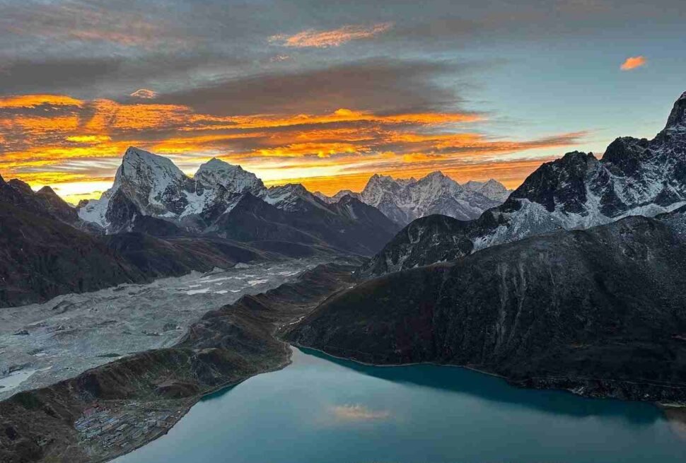
The Gokyo Lakes
Five blue and green glacial lakes sit in the Gokyo valley. The water gets its color from tiny particles of glacial rock suspended in it. The upper two lakes are rarely visited. Even the lower ones are nearly empty outside peak season. They sit between 4,700 and 4,900 m above sea level.
Sleeping and Eating on the Trek
The whole route is served by teahouses. These are small mountain lodges run by local families. They provide a room, food, and sometimes warm water for washing.
Rooms are simple. The mattresses are thin. Your sleeping bag is not optional because the teahouse blankets are not warm enough above 4,500 m.
Food is available all the way to Gorak Shep. The main dish is dal bhat, which is rice with lentil soup. You can also order noodle soup, eggs, pancakes, Tibetan bread, and pasta. The choice gets smaller above Lobuche.
Most teahouses have a main room with a stove. Bedrooms are not heated. This is why your sleeping bag earns its price.
Showers exist in bigger villages like Namche and Dingboche. A real warm shower becomes very rare above 4,500 m.
Electricity and internet exist in lower villages. They become patchy and expensive above Dingboche. Expect to pay USD 2 to 5 per hour for Wi-Fi and USD 3 to 5 to charge your phone.
In October and November, the most popular teahouses in Namche, Dingboche, Gorak Shep, Gokyo, and Lobuche fill up fast. Book ahead or ask your guide to call ahead each day.
Should You Hire a Guide?
A licensed Nepali guide costs USD 30 to 40 per day. For a 19 day trek that is USD 570 to 760. That is real money. Here is what you get for it: someone who knows the route in all weather, watches you for signs of altitude sickness, handles teahouse bookings, speaks Nepali, knows when Cho La is safe to cross, and can get help fast if something goes wrong.
A porter, who carries your main bag, is a separate hire at USD 25 to 35 per day. Some people hire a guide and porter combined into one person to reduce cost.
Hire a guide if you have never been to the Khumbu before, if you are going in shoulder season, or if you are travelling alone.
Wildlife Inside Sagarmatha National Park
The entire trek passes through Sagarmatha National Park. The park was created in 1976 and covers 1,148 square kilometers. It is a UNESCO World Heritage Site.
Animals You Might See
| Animal | Where | Notes |
|---|---|---|
| Himalayan Thar | Rocky slopes above 3,500 m | A mountain goat. Common near Namche. |
| Musk Deer | Forest sections below 4,000 m | Shy. More active at dawn and dusk. |
| Snow Leopard | Very rare anywhere on route | Present in the park but almost never seen. |
| Red Panda | Lower forests | Very rare. It is an endangered species. |
| Himalayan Griffon | Flying above valleys | A large bird of prey. Seen often on warm days. |
| Blood Pheasant | Juniper and forest zones | Seen in the lower parts of the route. |
| Yaks | Along the whole route | Kept by Sherpa families for carrying loads. Not wild. |
Below 4,000 m the trail goes through birch, pine, and juniper trees. In April the lower slopes turn red and pink from the rhododendron flowers. Above the tree line the ground becomes bare rock and ice.
Sherpa Culture Along the Way
The Khumbu is Sherpa territory. The Sherpa people came from Tibet around 500 years ago. Their culture and Buddhist faith are woven into everything along this route.
Tengboche Monastery at 3,870 m is the most important monastery in the Khumbu. The prayer hall holds a large statue and the building hosts the Mani Rimdu festival each year in October or November. Respectful visitors are welcome inside.
Khumjung Village sits just above Namche. It is a traditional Sherpa village with a school started by Sir Edmund Hillary’s Himalayan Trust in 1961.
Mani walls and prayer flags are found across the whole route. Always pass a mani wall on the left side, keeping it to your right hand. Walk clockwise around stupas.
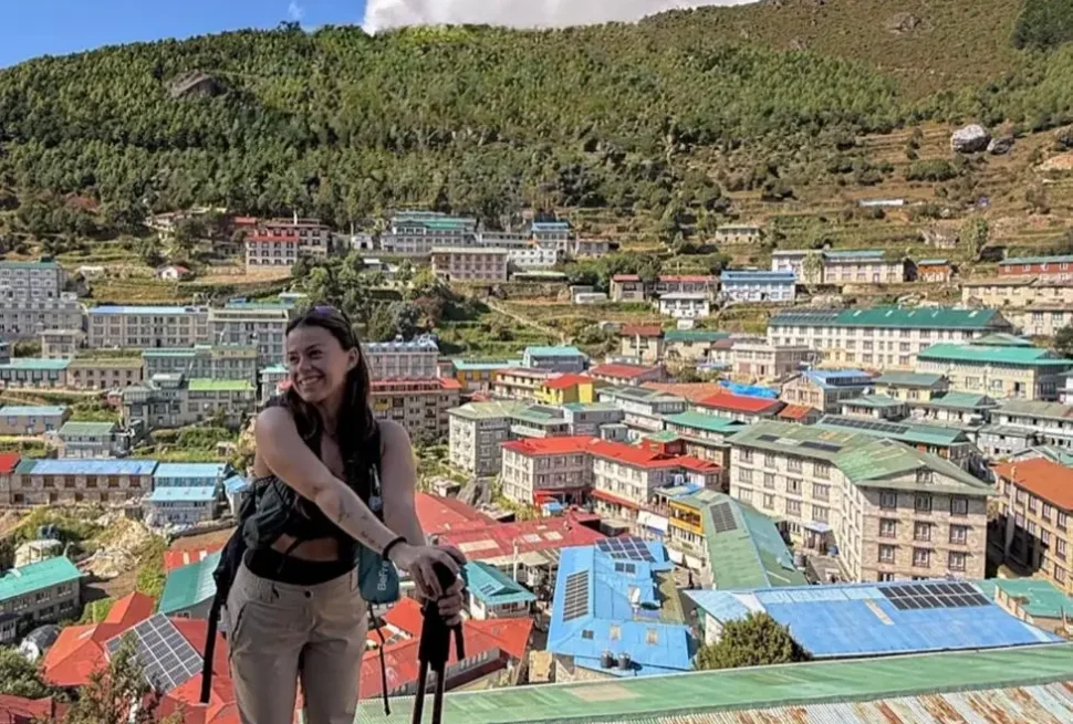
Namche Bazaar at 3,440 m is the main trading town of the Khumbu. The Saturday market has run for hundreds of years. Namche has good bakeries, coffee shops, and gear stores. Enjoy it because everything gets simpler above this point.
Take off your shoes when entering a monastery or a home. Ask before taking photos of people or sacred sites. Do not touch offerings or sacred objects. Tip your guide and porter well.
Common Mistakes That End the Trek Early
Going Too Fast
The single biggest and most dangerous mistake. Cutting the trek down to 14 or 15 days raises the risk of altitude sickness a great deal. The 18 to 21 day plan exists for a reason.
Not Listening to Early Warning Signs
A mild headache while walking can feel normal. A strong headache that stops you sleeping at night, combined with feeling sick, is not normal. It is altitude sickness. Trekkers who push on thinking it will go away are the ones who end up needing a rescue flight.
Running Out of Cash
There are no ATMs after Namche Bazaar. Many trekkers end up short of cash in small villages above 4,000 m. Take out extra money in Kathmandu and add more in Namche before moving higher.
Buying Poor Gear for the Main Items
A down jacket that stops working at 5,400 m is a safety problem, not just uncomfortable. A sleeping bag rated for only a few degrees below zero means terrible nights that pile up into total tiredness. Do not save money on your sleep system and insulation layers.
Getting Insurance That Does Not Cover This Height
Many basic travel insurance plans stop covering you above 4,000 or 5,000 m. Read what your policy actually says. You need cover that works above 5,500 m and includes helicopter rescue.
Not Checking the Weather Before Cho La
The Cho La glacier can become really dangerous after new snow falls overnight. Talk to trekkers coming from the other direction. Ask your guide. Be willing to wait a day if the pass is not safe.
Not Wearing Your Boots Before the Trek
Blisters that start on day two become a serious problem by day eight. Walk in your trekking boots for at least four to six weeks before your trip to break them in.
How to Train for This Trek
You do not need to be a professional athlete. But you do need real fitness.
The Minimum Standard
You should be able to walk 6 to 8 hours without stopping, carrying a 6 to 10 kg bag. You should be able to cover 15 to 20 km per day on hilly ground. You should be able to do this for many days in a row.
A 12 Week Training Framework
| Phase | Weeks | What to Do |
|---|---|---|
| Build base | 1 to 4 | Walk daily, 5 to 8 km. Do cardio 3 times a week: cycling, swimming, or running. |
| Add strength | 5 to 8 | Walk on hills with a loaded bag. Do squats, lunges, and step ups twice a week. |
| Build up time | 9 to 11 | Two weekend walks of 15 to 20 km. Increase bag weight to 8 to 10 kg. |
| Wind down | 12 | Reduce the amount of exercise. Rest and eat well. |
Your legs will be tested the most on the way down from the passes. The drop from Renjo La and Kongma La is long and steep. Work on your quad muscles and your knees in training.
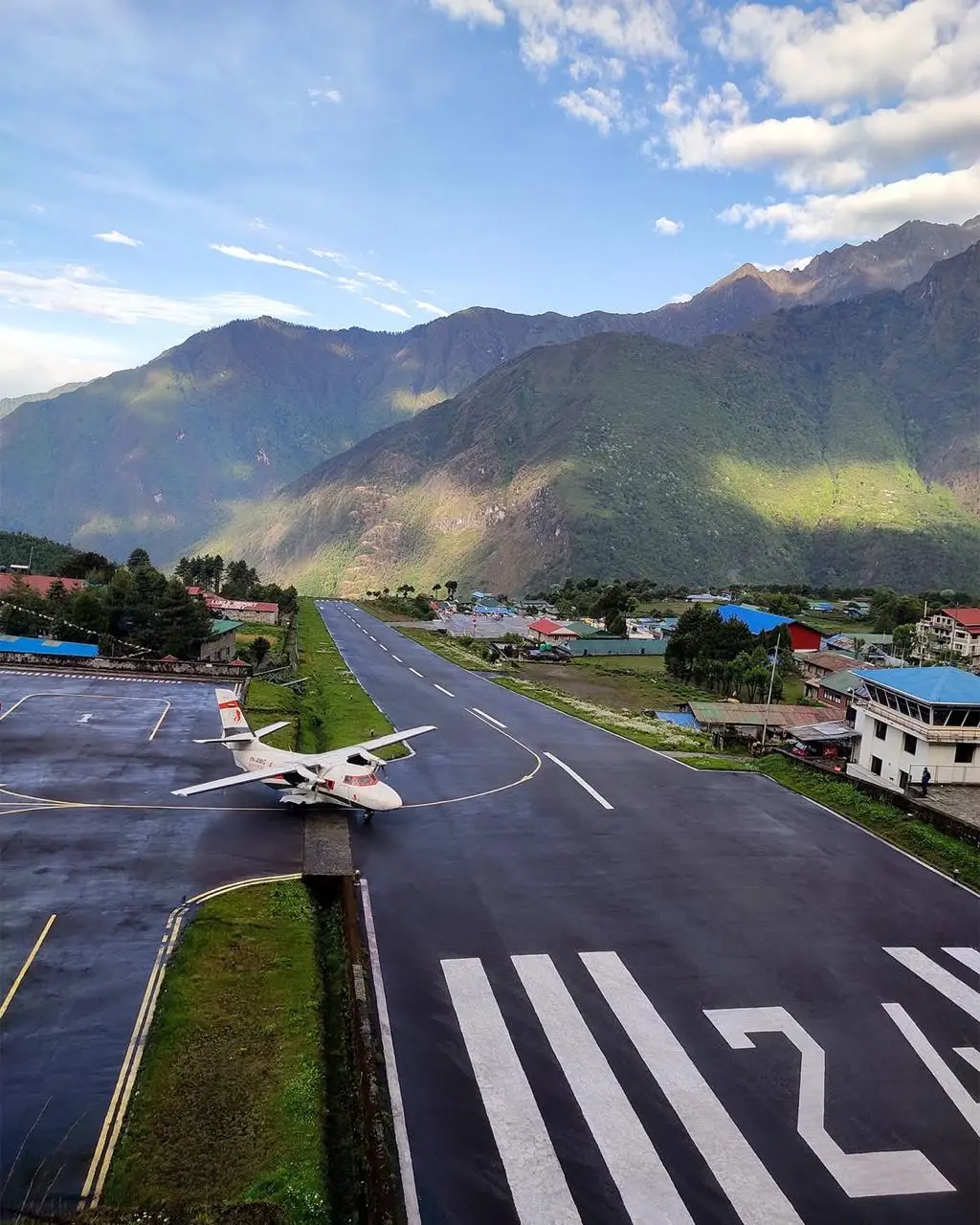
The Lukla Flight: What to Know
Almost everyone flies into Lukla from Kathmandu. The airport is called Tenzing Hillary Airport and sits at 2,840 m. The runway is 527 meters long and sits on a slope with a mountain at the far end.
Flights run on small aircraft with 12 to 20 seats. The flight takes about 30 to 40 minutes. One way costs about USD 170 to 200.
Flights can only take off when the weather is clear. Fog, cloud, or strong wind can ground all flights. Delays are common. Always add at least one or two spare days at each end of your trip. Never book an important flight home for the same day as your Lukla departure.
Going Solo or with a Group?
| Factor | Going on Your Own | Joining an Agency |
|---|---|---|
| Freedom | High. Walk at your own speed. | Low. Follow the group plan. |
| Cost | Lower if you skip a guide. | Higher as a package. |
| Safety | Lower if something goes wrong. | Higher. Guide deals with problems. |
| Social | Up to you. | Built in. |
| Planning | All on you. | Agency does it. |
| Permits | You sort them out. | Agency sorts them. |
| Best for | People with experience at high altitude. | Most people, especially first timers. |
Most trekkers on this route go with a guide, even those who consider themselves experienced. The glacier on Cho La, navigation in bad weather, and altitude risk all make having a good Nepali guide worth the cost.
How to Protect the Environment Here
Sagarmatha National Park gets tens of thousands of visitors each year. The effect is visible. Waste at high camps, worn out trails, and pressure on water and fuel.
What you can do:
Use a reusable water filter bottle and say no to plastic bottles at teahouses. Carry out anything you carry in. Stay on the marked trail to stop the ground from wearing away. Do not give money or sweets to children along the trail. Support teahouses that are locally owned. Keep your distance from wildlife and do not feed animals. Eat teahouse meals rather than bringing packaged food from below.
The permit fees you pay go toward trail care, conservation, and local community work.
Frequently Asked Questions
Can I do this trek without a guide? You can. There is no rule saying you must have a guide on this specific route as of 2025. But it is not a good idea for most people. The glacier on Cho La, route finding in bad weather, and altitude emergencies all go much better with an experienced guide.
Is this harder than Everest Base Camp? By a lot. This trek is longer, goes higher, and involves three pass crossings. Everest Base Camp has no pass crossings at all. If you have done EBC, this is the next step up.
How many people do not finish? No official number is kept. Based on reports from guides and trekkers, roughly 15 to 25 percent of people turn back or change their route because of altitude sickness. Good rest days cut this number down greatly.
Do I need mountain climbing experience for the Cho La glacier? No. It is serious trekking, not mountain climbing. Microspikes and trekking poles are enough in normal conditions. In very icy or heavy snow conditions, your guide may use a rope for extra safety.
What about phone signal and internet? Nepali SIM cards from NTC or Ncell work in most big villages. Above Lobuche and in the Gokyo valley the signal drops out often. Wi-Fi at teahouses is slow, unreliable, and charged per use. Download offline maps such as Maps.me or Gaia GPS before you leave Kathmandu.
Wildlife and Nature at a Glance
| What | Found Where |
|---|---|
| Himalayan Thar goat | Rocky slopes, common near Namche |
| Musk deer | Forests below 4,000 m |
| Snow leopard | Extremely rare, present but almost never seen |
| Red panda | Low forest areas, very rare |
| Himalayan Griffon | Soaring above valleys |
| Rhododendron forest | Below 4,000 m, beautiful in April |
| Ngozumpa Glacier | Nepal’s largest, visible from Gokyo Ri |
| Five Gokyo Lakes | Between 4,700 and 4,900 m |
Is the Three Passes Trek Worth Doing?
Yes. Without question, if you are ready for it.
This is not a trek you fall into without thought. It asks for proper preparation, real fitness, and the willingness to deal with cold rooms, hard ground, and long days. The teahouse blankets are thin. The pass crossings start in the dark. Some days will simply be very tough.
But the reward matches the effort. Watching the sun hit Everest’s summit from Renjo La at 6 in the morning. Crossing the Cho La glacier with ice all around you. Standing on Kala Patthar before the rest of the world wakes up.
The Three Passes Trek shows you the Khumbu as it actually is. Big, raw, and not the least bit interested in how hard you have trained. That is the whole point.